The proposed alignment for the crucial Gurgaon–Faridabad–Noida Regional Rapid Transit System (RRTS) corridor is undergoing a significant review. This reassessment by the National Capital Region Transport Corporation (NCRTC) is a direct response to concerns raised by the Haryana Shahari Vikas Pradhikaran (HSVP) regarding potential impacts on specific land parcels and the environment.
Why the Alignment is Being Revisited
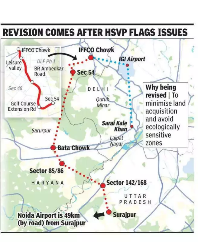
Officials from the NCRTC confirmed that the original alignment, detailed in the project report, was modified after HSVP flagged objections. The primary issue centered on the corridor's effect on several land pockets, particularly in Gurgaon's Sector 29. While a revised plan spared most of HSVP's land in this sector, it still impacted two to three parcels, prompting the need for further scrutiny.
Exploring Alternative Routes: Elevated vs. Underground
To address these challenges, NCRTC has put forward multiple alternative alignments for consideration. Each option presents a different trade-off between land use, cost, and environmental protection.

The first major alternative proposes an elevated corridor. This route would run along the Golf Course Extension Road and BR Ambedkar Road, pass through the Leisure Valley area, and terminate at IFFCO Chowk. A key feature of this plan is the integration with the existing Rapid Metro network, which would require extending that corridor by approximately 800 metres. Although this option would increase the total RRTS corridor length by about 2.7 kilometres, it offers a significant environmental advantage: it would completely bypass the sensitive Tau Devi Lal Biodiversity Park.
The second prominent option involves constructing an underground stretch. This alignment would take the corridor below ground along Sector 29 road, behind the Gymkhana Club, and further through Sector 53. The primary benefit of this underground route is that it would minimize impact on HSVP plots and avoid the biodiversity park entirely. However, this comes at a steep financial cost, with estimates suggesting the underground section would add roughly Rs 1,322 crore to the project's budget.
Decision Pending After Comprehensive Evaluation
The Managing Director of Haryana Mass Rapid Transport Corporation (HMRTC) has formally sought detailed feedback from HSVP on all revised alignments before making a final recommendation. An HSVP official stated that the alignment remains under active consideration, with no final decision made yet.
"We have shared our observations and suggested some modifications wherever land impact was noticed," the official said. "Multiple options are being examined to balance land impact, cost, and environmental concerns. No final decision has been taken yet. The alignment will be finalised after evaluating all options and whichever proposal is found to be the best for the city."
The Gurgaon–Faridabad–Noida corridor is a vital infrastructure project for long-term regional connectivity. It is designed to link the Indira Gandhi International Airport in Delhi with the upcoming Noida International Airport in Jewar. According to draft plans, the corridor will start at IFFCO Chowk in Gurgaon, pass through Sector 54, enter Faridabad at Bata Chowk, proceed through the Sector 85-86 intersection towards Noida Sector 142/168, and eventually connect to the Jewar airport via Surajpur.
The entire route is planned to feature six stations and carries an estimated project cost of around Rs 15,000 crore. Once completed, it will be the third RRTS corridor to traverse the state of Haryana, marking a major step in integrated transport for the National Capital Region.