Delhi Schools Get Digital Makeover: AI Mapping to Fix Crumbling Infrastructure
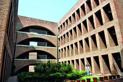
Government school buildings in Delhi face serious problems. Classrooms crumble. Roofs leak. These issues will now come under a digital microscope.
Delhi government is making a major shift. They are moving away from paper files and superficial repairs. Instead, they plan to hire a specialized professional agency. This agency will digitally map every government school in the capital.
Real-Time Monitoring for Better Schools
The new system promises real-time monitoring of infrastructure, safety, and upgrade work. It aims to ensure that repairs done on paper actually happen on the ground.

Digital profiles will track every brick, beam, and basic facility. This covers more than one thousand school campuses across Delhi. Authorities will use a single, centralized platform. They can track construction quality, building safety, and facility upgrades easily.
Pilot Project Shows Success
The government already tested this model. They ran a pilot project at a government school in Narela. Officials described the pilot as successful. Based on these positive results, the government decided to scale the system. It will now cover all government schools in the city.
Each school will undergo a thorough digital assessment. The assessment will cover many critical areas:
- Structural stability of buildings
- Condition of classrooms and toilets
- Availability of drinking water and electricity
- State of laboratories and libraries
- Sports facilities and fire safety arrangements
- Accessibility for children with disabilities
Schools currently under construction or renovation will also be tracked. The system will monitor work quality, timelines, and compliance with standards.
Automated Alerts and AI Power
Officials explain how the system will work. It will automatically flag gaps. This happens by comparing live data with established benchmarks. These benchmarks come from CBSE norms and National Disaster Management Authority guidelines.
"Instead of waiting for inspections or complaints, the system will generate alerts where deviations are detected," an official said.
At the core of this initiative is an AI-enabled infrastructure profiling system. Officials believe this will fundamentally change how school assets are monitored and maintained.
"The objective is to create an inventory of school infrastructure that reflects on-ground reality, not just official files," another official stated.
Building the Digital Database
To build this comprehensive database, the selected agency will use advanced technology. They plan to deploy a mix of methods:
- Drone-based surveys for aerial views
- GPS-enabled tagging for precise location data
- 360-degree imaging for detailed interior visuals
These tools will feed into a dedicated digital platform. The platform standardizes data and allows school profiles to be updated as improvements are made.
"This will give administrators customised analytical reports on what needs urgent repair, what requires structural intervention and what can be planned over the long term," the official added.
Targeted Funding and Reduced Disparities
Experts welcome the digital mapping initiative. They say it will help the education department quickly identify schools lacking basic infrastructure or safety features.
This enables targeted allocation of funds instead of uniform spending. The approach is expected to reduce disparities between schools. It ensures resources are directed where they are most needed.
"The initiative will strengthen transparency, fix accountability for contractors and officials and shift school infrastructure management towards evidence-based governance," the official explained. "We are using technology to ensure safer and more resilient learning environments."
Students Join the Survey Teams
Students will also play an important role in this process. Undergraduate engineering students and Class XII pass-outs will support field surveys. They gain hands-on exposure to real-world engineering and urban planning.
Their tasks will include several practical activities:

- Conducting physical inspections of school buildings
- Capturing drone footage of campuses
- Recording room-by-room 360-degree visuals
- Uploading data through a web-based application
They will assess classrooms, laboratories, furniture, toilets, and electrical fittings. Each item will be categorized by its current condition.
This comprehensive digital mapping represents a significant step forward. It moves Delhi's government schools from outdated paper records to modern, technology-driven infrastructure management. The goal is clear: create safer, better-equipped learning environments for all students.