Ahmedabad Lake 'Expansion' Sparks Controversy After Demolition Drive
The recent demolition of illegal structures around Chandola lake in Ahmedabad has unexpectedly revealed a significant town planning error, causing controversy among authorities. What initially appeared to be an expansion of the lake area has turned out to be a bureaucratic mistake that remained undetected for years.
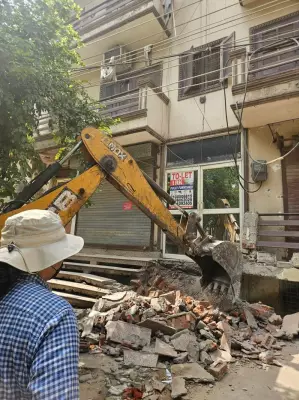
Massive Demolition Drive Uncovers Discrepancy
Ten months ago, the Ahmedabad Municipal Corporation (AMC) launched a concerted drive against encroachments around Danilimda lake, removing over 12,000 illegal structures. This aggressive action was part of a broader initiative to reclaim public spaces and restore the lake's original boundaries. The demolition operation, which began on April 29, 2025, saw the AMC and city police clearing approximately 100,000 square metres of illegal settlements on the first day alone.
By May 5, 2025, authorities had successfully removed more than 12,000 illegal constructions and encroachments, effectively opening up all of Chandola lake's land for public use. This massive clearance operation was hailed as a significant achievement in urban governance and environmental restoration.

The Shocking Discovery of Lake 'Expansion'
Following the demolition, a startling discrepancy emerged when comparing data from different government departments. The town planning department's records showed the lake area as 12.4 lakh square metres, while government revenue records listed it as 12 lakh square metres - a difference of approximately 40,000 square metres.
Upon investigation, it was discovered that the town planning department had mistakenly included government land as part of the lake area in their calculations. This error had gone unnoticed for years, only coming to light after the demolition drive created an opportunity for closer scrutiny of land records.
Root Causes and Corrective Measures
The controversy traces back to town planning schemes created a decade ago in the Danilimda area, where the lake's land was systematically divided. Errors made by town planning committee officials during the drafting of these schemes remained undetected until recently.
The situation came to a head when the resident additional collector of Ahmedabad district wrote to the AMC town planner, requesting the allocation of a joint final plot for government and private land near Chandola lake. This request triggered a comprehensive investigation by the corporation, which ultimately revealed the surprising details of the lake's apparent 'expansion.'
Approved Corrections and Future Safeguards
In response to these findings, the town planning committee has recently approved a proposal to correct the error in land classification. Additionally, authorities identified errors in the final allocation of plots outside the lake's area and have approved necessary corrections.
A new record has been proposed to rectify these errors in the town planning scheme, ensuring that future development around the lake follows accurate land measurements and classifications. This corrective action aims to prevent similar discrepancies from occurring in other urban planning projects across Ahmedabad.
The controversy highlights the importance of accurate land records and inter-departmental coordination in urban planning. While the demolition drive successfully removed illegal encroachments, it also exposed systemic weaknesses in land documentation that require immediate attention and reform.