NASA-ISRO Satellite NISAR Begins Comprehensive Soil Moisture Mapping of India
BENGALURU: The NASA-ISRO Synthetic Aperture Radar (NISAR) satellite has commenced systematic scanning of the entire Indian landmass, introducing a revolutionary method for monitoring one of agriculture's most vital yet elusive parameters: soil moisture content. This advanced space-based observation system is poised to transform how India manages its agricultural resources and responds to environmental challenges.
High-Resolution Monitoring Every 12 Days
Utilizing sophisticated radar instruments operating in both S- and L-band frequencies, NISAR captures detailed images of the country every 12 days, covering extensive areas with remarkable precision. Scientists have successfully demonstrated that this satellite data can be converted into comprehensive soil moisture maps at an exceptionally fine scale of 100 meters. For a nation where agriculture remains deeply dependent on monsoon patterns, this level of detailed information represents a significant technological breakthrough.
"Soil moisture serves as a critical indicator of crop health, irrigation requirements, and drought vulnerability," explained ISRO officials. "Historically, large-scale monitoring has primarily depended on weather data and limited ground-based stations. With NISAR's radar-based methodology, moisture levels can now be consistently evaluated across India's diverse geographical regions, from the irrigated agricultural belts of northern India to the rain-dependent farming areas of central India and the semi-arid zones of western India."

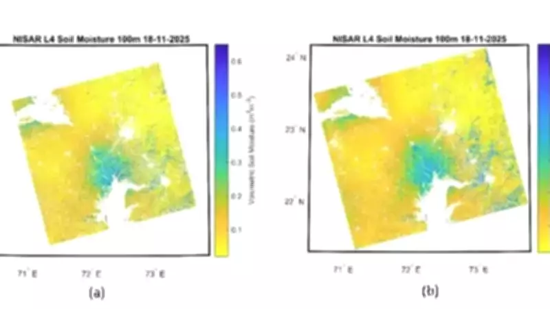
Advanced Algorithm Development and Scientific Validation
The retrieval algorithm powering these soil moisture products has been meticulously developed by ISRO's Space Applications Centre (SAC). Researchers emphasize that this physics-based model ensures scientifically robust estimates suitable for operational agricultural applications. Initial demonstrations have revealed distinct moisture patterns across different agro-climatic regions, with semi-arid areas in western India showing clear moisture stress, irrigation-driven variations visible in the Indo-Gangetic plains of northern India, and rainfall-dependent wetness patterns evident in central India's rainfed zones.
"These comprehensive results indicate that the NISAR system can effectively capture both broad regional trends and localized variability," ISRO confirmed. "This dual capability makes the satellite data particularly valuable for agricultural planning and resource management."
Dual-Frequency Radar Technology Advantages
One of NISAR's most significant technological strengths lies in its dual-frequency radar design. The L-band radar possesses superior penetration capabilities through vegetation and crop cover, providing crucial insights into subsurface moisture conditions. Meanwhile, the S-band radar offers enhanced sensitivity to surface conditions and delivers finer spatial detail. Scientists believe that integrating data from both frequencies will substantially improve measurement reliability across India's diverse cropping systems and agricultural landscapes.
Operational Implementation and Data Accessibility
To support national agricultural operations, 100-meter Level-4 soil moisture products will be routinely generated at ISRO's National Remote Sensing Centre (NRSC). These valuable datasets will be disseminated through the Bhoonidhi Portal, making critical information accessible to farmers, agricultural planners, researchers, government agencies, and non-governmental organizations. Each 12-day observation cycle will provide two separate measurements, enabling near-real-time tracking of evolving soil conditions across the country.
This frequent monitoring capability could significantly strengthen irrigation planning, enhance drought preparedness, and improve agrometeorological advisories at both district and community levels. "Before full operational deployment, the soil moisture products are undergoing rigorous evaluation at calibration and validation sites throughout India," ISRO noted. "Ground-based soil moisture sensors are being utilized to verify and refine satellite estimates across different soil types, rainfall patterns, and cropping systems."

Future Developments and Agricultural Applications
Additional research is currently underway to develop even finer field-scale products capable of capturing moisture variations within individual farm boundaries. If successfully implemented at scale, NISAR's comprehensive soil moisture maps could become fundamental tools in data-driven agriculture, directly connecting space-based observations with practical decisions made in agricultural fields throughout India. This technological advancement represents a major step forward in precision agriculture and sustainable resource management for the world's second-largest agricultural producer.