Zealandia: Earth's Eighth Continent Discovered Beneath Pacific Waters
At first glance, the world map appears settled and familiar, with continents fixed in their positions and clearly defined boundaries. However, this conventional understanding of Earth's geography has been quietly challenged by geologists over recent decades. Their research has revealed a remarkable geological secret hidden beneath the waves of the southwest Pacific Ocean.
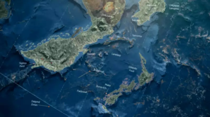
The Discovery of a Submerged Continent
One particular region in the southwest Pacific has consistently captured scientific attention due to its unusual characteristics. This vast area, mostly submerged underwater and stretching around New Zealand and New Caledonia, does not behave like ordinary ocean floor. Known as Zealandia, this enormous expanse of continental crust covers approximately 4.9 million square kilometres, making it comparable in size to greater India before its collision with Asia.
Nearly 94% of Zealandia lies below sea level, which explains why it remained undetected for so long despite its massive scale. As geological data and mapping technologies have improved over time, the evidence supporting Zealandia's continental status has become increasingly compelling. This is not merely a scattered collection of islands but rather a coherent geological entity that meets all established criteria for continental classification.

Geological Evidence Supporting Continental Status
Continental crust differs fundamentally from oceanic crust in several key aspects. It is typically thicker, lighter in density, and composed of a wider variety of rock types. Zealandia exhibits all these distinguishing characteristics that set it apart from surrounding oceanic regions.
Seismic studies have revealed that Zealandia's crust measures significantly thicker than the typical seven-kilometre thickness of ocean floor crust. In certain areas, the crust extends to remarkable depths exceeding forty kilometres. Rock samples collected from islands and seabed locations within Zealandia include diverse formations such as granite, schist, greywacke, and limestone. These rock types contrast sharply with the basaltic formations that typically characterize oceanic crust.
Bathymetric mapping provides additional compelling evidence. Zealandia rises distinctly higher than the surrounding deep ocean basins, with edges that slope downward in patterns resembling the margins of other recognized continents. The geological outline demonstrates continuity rather than fragmentation into isolated pieces.
Ancient Origins and Geological Evolution
According to the comprehensive study titled "Zealandia: Earth's Hidden Continent," this submerged landmass was originally part of Gondwana, the ancient southern supercontinent that existed millions of years ago. Approximately eighty to ninety million years ago, Zealandia's crust began undergoing significant stretching and thinning processes.
This geological transformation weakened the crustal structure as Gondwana gradually broke apart. Zealandia subsequently drifted away from its neighboring landmasses of Australia and Antarctica. The thinning process created a unique balance that allowed Zealandia to maintain its continental characteristics while becoming buoyant enough to remain submerged beneath ocean waters.
This delicate equilibrium explains why the vast majority of Zealandia now lies underwater. Importantly, this is not simply "drowned land" in the conventional sense but rather continental crust that never fully re-emerged after its initial submersion.
Geological Continuity Across the Region
New Zealand and New Caledonia provide rare visible windows into Zealandia's otherwise hidden interior. Mountain belts, fault systems, and ancient rock formations continue offshore in predictable, consistent patterns that demonstrate geological continuity across the region.
Sedimentary basins distributed throughout Zealandia contain thick layers of sediment, sometimes reaching depths of several kilometres. These geological formations record the history of rifting, subsidence, and subsequent marine flooding that has characterized Zealandia's evolution. The patterns observed mirror those found in eastern Australia, which was once connected to Zealandia before their geological separation.

Clear Boundaries and Continental Scale
Size represents a crucial factor in geological classification. Zealandia's enormous area far exceeds that of features typically categorized as microcontinents. Clear physical boundaries also exist between Zealandia and neighboring Australia, particularly across the deep Cato Trough where distinct oceanic crust separates the two landmasses.
This separation is both physical and tectonic rather than merely geographical. When evaluated against standard geological definitions, Zealandia satisfies all established criteria for continental classification, including elevation patterns, geological composition, crustal structure characteristics, and overall scale.
Transforming Our Understanding of Earth's Geology
The recognition of Zealandia as Earth's eighth continent represents more than just the addition of another landmass to geographical maps. This discovery fundamentally changes our contextual understanding of continental geology and Earth's evolutionary processes.
Continental breakup, rifting, and thinning mechanisms can now be studied through a single, comprehensive submerged example. Zealandia demonstrates conclusively that continents do not necessarily terminate at shorelines but can extend far beneath ocean waters.
This remarkable discovery serves as a powerful reminder that Earth's surface continues to hold significant geological revisions waiting to be uncovered. Some of these revelations lie just beneath the ocean waves, awaiting sufficient scientific evidence to reveal their stories clearly and transform our understanding of planetary geology.