The Commission for Air Quality Management (CAQM) is set to revolutionize how India tracks agricultural fires with a new verification system that combines satellite technology with ground validation. By December 2025, the air pollution mitigation body expects to have significantly more accurate data on stubble-burnt farms across northern India.
The Technology Behind the Tracking
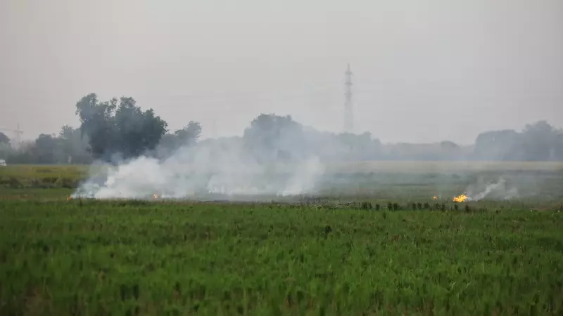
This groundbreaking initiative involves multiple agencies working in coordination, including the National Remote Sensing Centre (NRSC), remote sensing centers in Punjab, the Haryana Space Applications Centre, district authorities, and the Indian Council of Agricultural Research (ICAR). The European Space Agency's Sentinel-2 satellite, which captures high-resolution images at 10 meters, serves as the primary data source, passing over the region every five days.
Scientists are utilizing a sophisticated combination of optical images, near-infrared images, and short-wave infrared imaging to detect burn scars on agricultural fields with unprecedented precision. Since stubble fire monitoring began on September 15, 2025, fortnightly estimates on burnt areas have been available internally, providing regular updates on the situation.

Ground Validation for Accuracy
The critical component that sets this initiative apart is the extensive ground truthing exercise currently underway. Authorities in Punjab and Haryana are using a specialized application developed by NRSC to feed verified data on actual burnt areas, creating a robust testing environment for the satellite data's accuracy.
A government official explained the practical benefits: "If we discern that fire counts in an area are fewer, but the area burnt is large, it gives a better picture of the situation on ground to enforce laws and rules." This approach addresses the longstanding problem of stubble fire undercounting that has plagued previous monitoring efforts.
Addressing Delhi's Air Quality Crisis
The timing of this technological advancement couldn't be more critical. On Wednesday, November 12, 2025, Delhi's air quality measured 418 on the Central Pollution Control Board's index, categorizing it as severe. The Indian Institute of Tropical Meteorology's Decision Support System revealed that stubble burning contributed to 15.45 percent of PM 2.5 concentration in Delhi that same day.
Stubble burning remains one of the primary contributors to Delhi-NCR's winter air pollution crisis, accounting for as much as 35% of emissions on some days in November 2024. The Supreme Court has taken cognizance of the issue and directed CAQM to improve enforcement against stubble burning by obtaining more comprehensive satellite data.
While a pilot program was initiated last year, full-fledged testing is now underway with substantial ground validation expected to continue until late this year. Authorities anticipate that the finalized burnt area mapping protocol will be fully operational by next winter, providing a powerful tool in the ongoing battle against air pollution in northern India.