
Residents of Chennai woke up to an unexpectedly drenched Monday morning as Cyclone Ditwah, which had weakened a day earlier, staged a dramatic resurgence over the Bay of Bengal. The system unleashed one of the wettest spells of the season, catching the city off guard and disrupting daily life.
From Deep Depression to Soaking Surprise
On a breezy Sunday evening, Cyclone Ditwah had weakened into a deep depression, leading the India Meteorological Department (IMD) to downgrade its alert for Chennai to yellow. However, the system moved northward through the Bay overnight, gathering significant moisture. By Monday morning, drifting slowly at just 5km per hour and edging closer to the coast, it thickened cloud cover over the city and its suburbs.
Steady, prolonged showers began from 5 am, dumping torrential rain over several areas. Between 8:30 am and 7:30 pm, the city recorded a 'moderate' average rainfall of 10cm, with northern parts and neighbouring districts bearing the brunt.

Record Rainfall and Widespread Disruption
The rainfall figures revealed the intensity of the downpour. Ennore, within Greater Chennai Corporation limits, topped the charts with 13cm of rain between 8:30 am and 2 pm. Areas like Parry’s Corner, Ice House, Madhavaram, Saligramam, and Vadapalani each saw over 10cm. Nungambakkam recorded 9.45cm, while Meenambakkam registered 6.2cm.
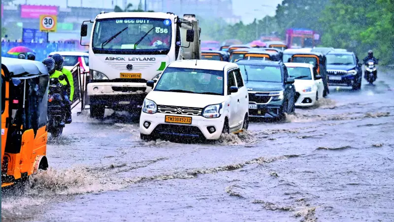
The consequences were immediate and severe. Low-lying areas were inundated, children trudged to school soaked to the skin, and traffic across most of the city slowed to a painful crawl. As commuters navigated waterlogged streets and potholes during the morning rush, the IMD took action. Around 10 am, it reinstated an orange alert (warning of very heavy rain) for Chennai and a more severe red alert (for extremely heavy rain) for Tiruvallur district.
Uncertain Path and Forecast Ahead
The future trajectory of Cyclone Ditwah remained a point of discussion among forecasters. The IMD predicted the system would fade into a depression and cross land near Nellore in Andhra Pradesh early on Tuesday. It forecast heavy rain for Tuesday in Chennai, Tiruvallur, Kancheepuram, and Chengalpet.
Independent weather bloggers, however, offered a slightly different view. Noted blogger Pradeep John suggested the depression would linger 30-40 km offshore near Chennai for the next 36 hours, leading to scattered bursts of rain in the city and surrounding districts. He explained that the system was currently stuck, unable to move west or east, and its movement depended on a westerly trough influence possibly moving away by Wednesday.
As Chennai recovers from the sudden deluge, authorities and citizens remain on alert, watching the slow-moving system in the Bay of Bengal for its next move.


