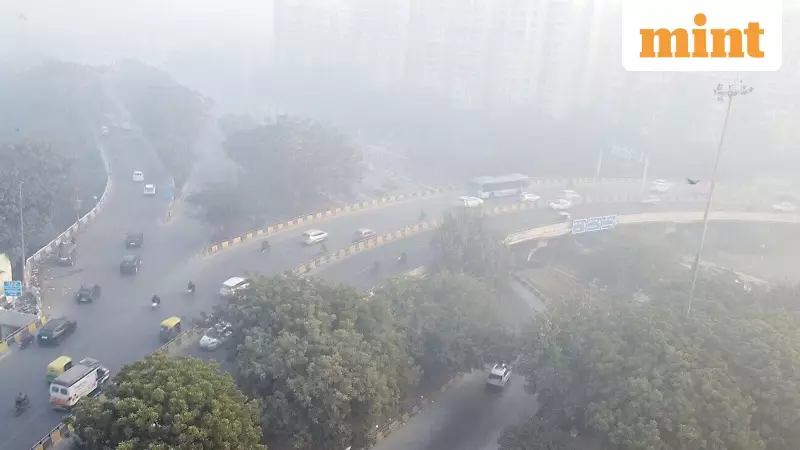
Delhi Gripped by Sudden Flash Fog and Biting Cold
Residents of Delhi woke up to an unusually harsh winter morning on Wednesday. The capital city shivered as temperatures dropped sharply to a low of 3.8 degrees Celsius. This reading came from the Safdarjung weather station, which serves as Delhi's primary meteorological observatory.
A Rapid Blanket of Mist Descends
Between 7:45 and 8:00 AM, a dramatic weather event unfolded across the city. A heavy, sudden blanket of mist swept over the landscape. This phenomenon reduced visibility to almost zero within moments, according to an India Today report. Weather experts identify this brief but powerful occurrence as "flash fog" or rapid-onset fog.
Flash fog develops and dissipates swiftly under specific atmospheric conditions. It poses unique challenges because it appears without much warning.

Why Did the Flash Fog Form?
Meteorologists point to a combination of factors for this sudden event. Cold wave patterns, high humidity levels, and abrupt changes in wind and temperature all played a role. The environment already held significant moisture from the previous night.
As dawn broke, instead of steady solar warming, a surge of chilled air arrived. This cold air resulted from shifting light winds. It caused surface temperatures to stall or drop instantly. This rapid cooling forced the air toward its dew point, triggering immediate condensation.
In high-moisture scenarios, even minor thermal fluctuations can yield dramatic outcomes. In metropolitan hubs like Delhi-NCR, atmospheric pollutants act as condensation nuclei. These particles provide water vapour with extra surfaces to attach to. Consequently, visibility can collapse to just several meters within minutes.
Stagnant air also contributed to the event. Lacking sufficient breeze to scatter the mist, the fog accumulated quickly over highways, neighbourhoods, and parks. Eventually, as the sun intensified, ground temperatures climbed enough to disrupt the fragile equilibrium. This warming, paired with a slight increase in air circulation, caused the droplets to revert into vapour. The fog didn't drift elsewhere; it essentially vanished on the spot.
Safety Hazards and Future Outlook
Such abrupt events are particularly hazardous. They catch drivers and aviation professionals by surprise. Unlike predicted overnight fog conditions, flash fog provides no time for alerts. This creates major safety hazards on roads and for flight operations.
As the winter season deepens, forecasters suggest these rapid fog incidents may return. They are likely to be brief, intense, and chaotic, much like Wednesday's unexpected occurrence.
Temperature Readings Across the City
Various weather stations recorded the morning's extreme cold:
- Safdarjung: 3.8°C (3.6 degrees below the seasonal average)
- Palam: 4.4°C (2.9 degrees below normal)
- Lodhi Road: 3.6°C
- The Ridge: 4.6°C
- Ayanagar: 4.0°C
Cold waves are officially declared when temperatures drop 4.5 to 6.4 degrees below normal. The maximum temperature for Wednesday is expected to reach around 20 degrees Celsius.
Air Quality Deteriorates Further
Delhi's air quality remained a serious concern on Wednesday morning. The overall Air Quality Index (AQI) stood at 357 at 7 am. This reading falls in the 'very poor' category, according to data from the Central Pollution Control Board (CPCB).
This marks a further deterioration compared to Tuesday. The city's AQI stood at 337 on the previous day.
Several areas across the national capital reported AQI levels well above 300. These persistently hazardous conditions pose risks to public health.
Specific area-wise AQI readings at 7 AM included:
- Anand Vihar: 366
- Bawana: 361
- Jahangirpuri: 420 (Severe category)
- RK Puram: 407
- Dwarka Sector 8: 403
- Punjabi Bagh: 366
- Wazirpur: 386
- Chandni Chowk: 397
The combination of extreme cold, sudden fog, and poor air quality created a challenging environment for Delhi's residents on this winter day.