ISRO Study Uncovers True Cause of Devastating Uttarkashi Flash Flood
A groundbreaking investigation by scientists from the Indian Space Research Organisation has revealed that the catastrophic flash flood that struck Dharali village in Uttarkashi on August 5, 2025, was triggered by an unexpected geological phenomenon rather than conventional weather events. The research conclusively demonstrates that the disaster originated from the sudden collapse of an exposed ice patch within the nivation zone of the Srikanta Glacier.
Satellite Analysis Reconstructs the Catastrophic Event
Utilizing advanced Earth observation technologies, including multi-temporal satellite imagery, high-resolution digital elevation models, and visual records, the ISRO team meticulously reconstructed the sequence of events. Their findings, published in the study titled 'Ice-patch collapse and early-warning implications from a Himalayan flash flood: emerging cryo-hydrological hazards under deglaciation', provide crucial insights into previously unrecognized mountain hazards.
The research team, comprising scientists Giribabu Dandabathula, Omkar Shashikant Ghatage, Subham Roy, Apurba Kumar Bera, and Sushil Kumar Srivastav, mapped the ridge-to-valley progression of the flood with unprecedented precision. Their analysis revealed that during the 2025 ablation season, exposed ice patches were detected in a nivation hollow—a high-altitude zone where perennial snow and buried ice persist beneath seasonal cover. Remarkably, such exposed ice patches had not appeared in nearly fifteen years of continuous satellite records.

The Mechanics of the Ice Patch Collapse
Satellite images from early July 2025 clearly showed exposed ice patches on steep north- to northeast-facing slopes at approximately 5,220 metres elevation. Post-event imagery from August 12 confirmed the complete disappearance of one such patch, covering about 0.25 square kilometers, along with fresh erosional scars downslope.
Even with a conservative ice thickness estimate of 0.3 metres, the authors calculated the collapsed volume at roughly 75,000 cubic metres, with a mass approaching 69 million kilograms. This enormous ice mass plunged more than 1,700 metres toward the Khir Gad channel, generating immense gravitational energy that transformed it into a high-velocity, debris-laden surge.
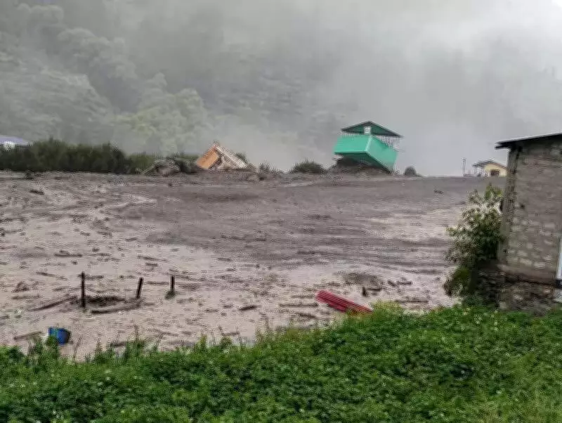
Although the total meltwater volume was relatively modest, steep gradients, sediment entrainment, and narrow channel confinement dramatically amplified its destructive impact, the study emphasized. Video footage recorded by local residents captured a brief but intense surge of water, mud, and debris, followed by prolonged lower-intensity flow—a pattern consistent with rapid mass release rather than monsoon flooding.
Ruling Out Conventional Causes
The ISRO investigation definitively eliminated traditional explanations for the disaster. Rainfall data from August 3-5 indicated only light to moderate precipitation, effectively ruling out a cloudburst as the trigger. Furthermore, the absence of glacial lakes in the upper catchment completely eliminated the possibility of a glacial lake outburst flood.
This finding aligns with earlier investigations by scientists from the Wadia Institute of Himalayan Geology and the Geological Survey of India, which had attributed the Dharali flood to slope instability linked to cryospheric changes. However, the ISRO study provides the specific mechanism: the collapse of an exposed ice patch rather than glacial moraine material.
It is crucial to distinguish between an ice patch and a glacial moraine. An ice patch represents a vertically layered mass of snow, firn, and ice that does not flow like a glacier and is highly sensitive to warming. In contrast, a glacial moraine consists of loose rock and debris deposited by glaciers.
Downstream Impacts and Broader Implications
Downstream satellite comparisons revealed significant widening of the Khir Gad channel, extensive bank erosion, and substantial sediment deposition at its confluence with the Bhagirathi river. Built-up areas in Dharali sustained considerable structural damage as debris-laden flows spread laterally across low-lying zones.

The research highlights how ongoing deglaciation in the Himalaya is exposing and destabilizing previously insulated ice bodies. Ice patches, once protected by layers of snow and firn, become mechanically vulnerable when exposed during prolonged warming periods. Their sudden disintegration represents an under-recognized but potentially severe cryo-hydrological hazard that requires urgent attention.
Critical Need for Enhanced Monitoring Systems
The authors stressed the pressing need for improved early-warning systems in vulnerable Himalayan regions. The detection of exposed ice patches in steep nivation hollows could serve as a precursor signal in high-risk catchments, they noted. However, frequent monsoon cloud cover limits optical satellite monitoring, underscoring the importance of integrating radar-based systems with ground observations for comprehensive hazard assessment.
Scientists concluded that the Dharali event broadens the spectrum of recognized glacier-related hazards in the Himalaya and underscores the urgent need to monitor emerging cryospheric instabilities as deglaciation accelerates. This research demonstrates how Earth observation data can effectively reconstruct complex cryo-hydrological hazards in remote mountain regions, providing valuable insights for disaster preparedness and climate adaptation strategies.