
Kolkata's Intense Nor'wester Storm Breaks Seven-Year March Rainfall Record
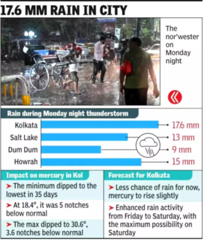
A fierce late-night nor'wester storm, accompanied by squally winds, swept through Kolkata on Monday night, dramatically altering the city's weather patterns. The intense thunderstorm activity delivered a significant 17.6 mm of rainfall, marking the highest single-day precipitation for March in seven years.
Temperature Plunge Following Storm Activity
The meteorological disturbance caused a sharp decline in temperatures across the city. Tuesday's minimum temperature plummeted to 18.4°C, representing a substantial five notches below the normal seasonal mark. This temperature drop ended a twelve-day streak where minimum temperatures had remained above normal levels.
The day temperature on Tuesday also experienced a notable decrease, falling 3.6 notches below the expected normal range. The storm's powerful winds reached peak speeds of 72 kmph, creating the first significant squall of the current season that rampaged through Kolkata and surrounding areas.
Historical Context of March Rainfall Patterns
Meteorologist HR Biswas, head of the Regional Meteorological Centre in Kolkata, provided historical perspective on the unusual weather event. "While May typically experiences the maximum number of nor'wester spells with high rainfall counts, some years witness similar activity in March, like what we encountered on Monday night," explained Biswas.
The current 17.6 mm rainfall measurement equals the highest 24-hour rainfall recorded in March 2020. This contrasts sharply with recent years where March precipitation has been significantly lower:
- 2024: Highest single-day rainfall of 12.4 mm
- 2023: Highest single-day rainfall of 8.9 mm
- 2022 and 2021: No rainfall recorded throughout entire month
- 2020: Highest 24-hour rainfall matching current measurement at 17.6 mm
Last year in March, Kolkata received only 5.1 mm of total monthly rainfall, with the highest 24-hour count reaching merely 2.5 mm.
Forecast for Coming Days and Weather Patterns
Meteorological officials indicate that rainfall chances have diminished for Kolkata in the immediate next two days due to changing wind patterns and reduced moisture content in the atmosphere. The city is currently experiencing predominantly dry westerly winds.
However, weather patterns are expected to shift by Friday, potentially bringing renewed thundershower activity to Kolkata and other parts of Bengal. "The chance of rain, especially in Kolkata, is now less due to changes in wind pattern and presence of less moisture quantity. But there will be enhanced thunderstorm activities over many districts from Friday onwards. For Kolkata, the highest chance is on Saturday noon onwards," added the RMC Kolkata head.
Weather experts anticipate that wind patterns will begin transitioning by Friday, potentially injecting more moisture into the atmosphere. This shift, combined with the possible influence of a passing western disturbance and trough line, could enhance thundershower activities across the region.
With reduced rainfall probability in the immediate forecast, temperatures are expected to rise slightly in the coming days before potential storm activity resumes toward the weekend.