Massive Land Conversion in Goa Under Section 39A Raises Environmental Alarms
Panaji: In a significant development, compiled data reveals that more than 530 hectares of land, equivalent to 53 lakh square meters, have been unlocked for settlement across Goa under Section 39A of the Goa Town and Country Planning Act. This extensive reclassification, primarily from orchard, agricultural, and natural cover to settlement, highlights a concerning trend where a mechanism intended for minor corrections has evolved into widespread environmental alteration.
Geographic Clustering of Development Pressure
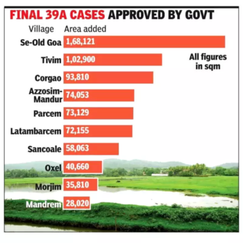
The data indicates a sharp geographic clustering, with over 51% of the total land converted under Section 39A concentrated in just five villages. This concentration is most visible in Pernem taluka, where development pressure is intensifying. Notably, Corgao in Pernem accounts for the single largest share, with 10.5 lakh square meters converted to settlement.
Top Five Villages by Conversion Area:

- Corgao (Pernem): 10.5 lakh sqm
- Sancoale (Mormugao): 7 lakh sqm
- Old Goa: 4.3 lakh sqm
- Parcem: 2.8 lakh sqm
- Tivim (Bardez): 2.6 lakh sqm
Together, these villages account for 27.2 lakh square meters of zone changes, representing more than half of all approvals granted under the section. Additional significant settlements have been recorded in Arambol (2,39,979 sqm), Mandrem (2,05,950 sqm), and Morjim (1,87,005 sqm). These figures include both final approvals and provisional land use change clearances.
Historical Context and Political Intervention
The clustering gains significance in light of earlier attempts to rezone Pernem through a taluka-level zoning plan. A report published on October 10, 2023, highlighted how the draft zoning plan for Pernem proposed converting 1.4 crore square meters, approximately 21% of the taluka's green cover protected under Regional Plan 2021, for development. This report prompted intervention from the Prime Minister's Office, leading TCP minister Vishwajit Rane to scrap the plan for taluka-level zoning.
However, the data now shows that the TCP department continued with incremental zoning changes, utilizing Section 39A as a mechanism to facilitate case-by-case land conversion. This approach has allowed for ongoing development despite the scrapping of broader plans.
Drivers of Conversion: Airport and Real Estate Demand
Local residents and real estate developers attribute the conversion spree to the opening of the Manohar International Airport. This greenfield airport has intensified land demand in Pernem and adjoining coastal belts, with real estate projections forecasting sustained price growth in North Goa, particularly in villages like Morjim, Mandrem, and Arambol. The conversion data aligns closely with this corridor of investment interest.
Beyond Pernem, Sancoale's 7 lakh square meter conversion footprint suggests a similar pattern. Situated between Goa's largest industrial estate and the Goa International Airport, the scale of settlement approvals there indicates a gradual shift from industrial or mixed land use to residential and commercial development.
Regional Imbalances and Environmental Concerns
A north-south comparison further underscores the imbalance in land conversion. The overwhelming share of the 53 lakh square meters converted under Section 39A is located in North Goa talukas of Pernem, Bardez, and Tiswadi. In contrast, South Goa accounts for a smaller and more fragmented share of reclassification.
The inclusion of villages such as Se-Old Goa and Latambarcem among higher conversion zones raises critical questions about the cumulative impact on heritage-adjacent and environmentally sensitive areas. This incremental zoning approach, often described as salami slicing, poses significant threats to Goa's eco-sensitive landscapes.
The data, sourced from the Goa official Gazette and augmented with information obtained through RTI, has been analyzed by PhD researcher Tahir Noronha, providing a comprehensive view of the ongoing land use changes in the state.