A remarkable archaeological find in Tamil Nadu has shed new light on the administrative and land survey practices of a historic South Indian dynasty. A team of archaeologists has unearthed a permanent land measuring rod, dating back to the Kongu Chola period, at the Kariyapiran Kovil in Tirupur district.
A Monumental Discovery on Temple Walls
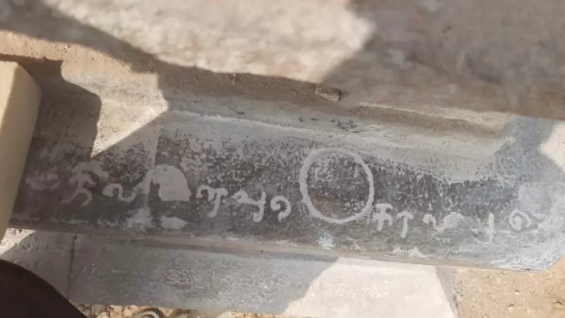
The significant discovery was made during an inspection led by archaeologist V Narayanamoorthy. The team found the 14-foot stone rod inscribed on the southern wall of the Kariyapiran temple, a Perumal shrine located in Komaralingam. This site sits on the western bank of the Amaravathi river. The inspection was conducted ahead of the planned renovation of the dilapidated temple, which itself originates from the 13th century AD.
In modern measurements, the ancient scale stretches 446 cm in total length. Archaeologist Narayanamoorthy detailed that the scale is distinctly marked, beginning and ending with a '+' mark measuring 6x6 cm. This permanent inscription on the temple wall served as a standardized reference, ensuring fair and accepted land measurements for the community.

First Evidence of Kongu Chola Measurement Systems
This discovery is groundbreaking because it provides the first physical evidence of the land measurement scales used during the Kongu Chola period (10th to 13th centuries AD). While historical inscriptions mentioned the use of measuring rods like the 'ulagalantha kol,' and land surveys were known to be conducted, no actual scale had been found until now.
"The newly discovered measuring rod can be considered the first evidence of a land measuring scale from the Kongu Chola period," stated Narayanamoorthy. He explained the practical use: a rope would be measured against this permanent scale and then used to survey plots of land. This public installation at the temple helped resolve boundary and area disputes amicably, as people trusted the impartial standard.
Symbols and Inscriptions Tell a Deeper Story
Adding to the significance, archaeologists found a unique circular symbol engraved alongside the measuring rod. "For the first time in the history of Tamil Nadu, a symbol used to measure the boundary stones has been found engraved alongside this measuring rod," Narayanamoorthy revealed. This symbol has a diameter of 8 cm.
An inscription next to the rod states it was established by an individual named Paalaiyapadiyan. This was done in the 20th year of the reign of Kongu Chola king Vikrama Chola, firmly placing it in the 13th century AD. The inscriptions also reference "Pulladi Karkal," which were boundary stones planted at the four corners of land measured using such rods, a common ancient custom.
This find at Kariyapiran Kovil is more than just an ancient ruler; it is a tangible link to the sophisticated governance, legal systems, and everyday life of the Kongu Chola era, offering invaluable insights for historians and archaeologists studying Tamil Nadu's rich past.