Advanced LiDAR Technology Uncovers 6,000 Years of Greek History
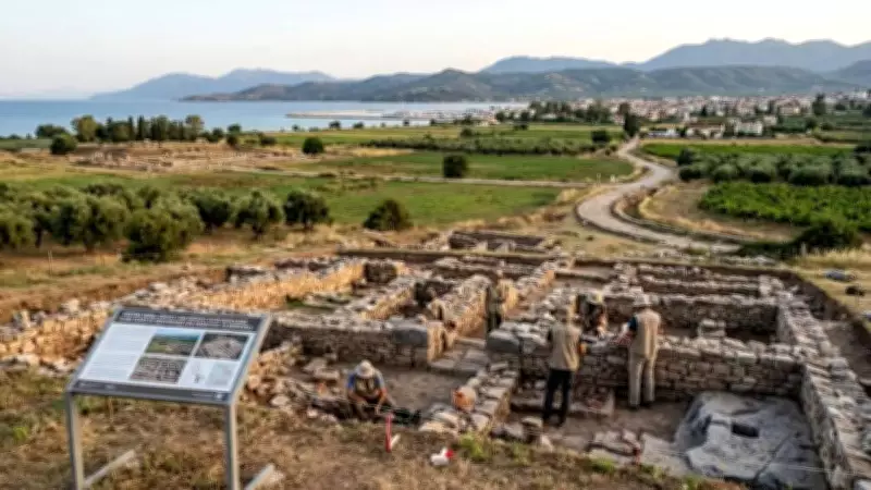
In a groundbreaking archaeological discovery, researchers have utilized cutting-edge technology to reveal the long-hidden architectural and economic foundations of an ancient Greek landscape. A comprehensive survey conducted by the Swiss School of Archaeology in Greece (ESAG) has successfully identified an extensive rural network comprising more than 200 distinct sites across the Eretrian plain region of Evia, Greece.
This remarkable find documents an impressive 6,000 years of continuous human activity, providing unprecedented insights into how communities evolved and sustained themselves from their earliest agrarian beginnings through to the end of the 19th century.
Revolutionary Survey Methodology
The survey, conducted between 2021 and 2025, employed state-of-the-art LiDAR (Light Detection and Ranging) technology to penetrate dense vegetation and document a complex rural organization that connects prehistoric settlements with medieval churches throughout the region. Researchers mapped more than 30 square kilometers of land, revealing ancient farms, industrial quarries, and medieval road systems that connected various demes (rural settlement areas) with the urban center of Eretria and the Sanctuary of Artemis at Amarynthos.

"The use of LiDAR as a remote sensing technology has been crucial to detecting hidden sites," according to the Swiss School of Archaeology in Greece Annual Reports. The technology enabled researchers to obtain high-resolution, three-dimensional terrain maps that revealed buried walls, terraces, and ancient routes otherwise invisible to traditional archaeological methods.
Unprecedented Historical Insights
Through extensive fieldwork, the archaeological team gained new understanding of the many settlements and administrative units that functioned as the hinterland of the ancient city-state. Many of these areas have been identified as separate demes, some resembling organized social units with distinct characteristics.
Key findings include:
- Documentation of existing rock-cut olive presses at most demes
- Extensive road systems that provided socio-economic and religious connectivity
- Connections between rural areas and populous regions like the Sanctuary of Amarynthos
- Evidence of continuous occupation despite changing rulers from Mycenaean to Roman and Ottoman administrations
By integrating LiDAR data into Geographic Information Systems (GIS), researchers analyzed factors influencing the spatial distribution of human activity over millennia in this significant part of Greece.
Enduring Communities Through Changing Empires
Artefacts discovered throughout the Eretrian plains demonstrate that the region maintained a persistent population despite numerous political changes. According to the Hellenic Ministry of Culture, while rulers shifted from Mycenaean to Roman and Ottoman administrations, a consistent agrarian population remained, tending farmland and maintaining agricultural operations for six millennia.
This continuity represents one of the most remarkable aspects of the discovery, showing how rural communities outlasted empires through adaptation and resilience.
Modern Significance and Heritage Protection
The comprehensive mapping of over 200 settlements serves two vital contemporary purposes. First, it significantly enhances our historical understanding of the area's development and organization. Second, and perhaps more importantly, it creates a foundation for protecting the region's cultural heritage under Greek law.
With increasing urban development pressures on Evia, this detailed mapping provides an essential record of archaeological heritage sites that existed in the area. This documentation will help mitigate the destruction of unexcavated cultural strata before they can be properly studied and preserved for future generations.
The research represents a perfect marriage of ancient history and modern technology, demonstrating how advanced scientific methods can unlock secrets of human civilization that have remained hidden for centuries while providing tools for cultural preservation in an era of rapid development.