China's Global Ocean Mapping Raises Submarine Warfare Concerns
China is significantly expanding its undersea mapping and monitoring operations across the Pacific, Indian, and Arctic oceans, gathering data that naval experts say could be critical for submarine warfare, according to a new report by Reuters. The expansion comes as Beijing seeks to improve its ability to deploy submarines and track adversaries in strategically sensitive waters.
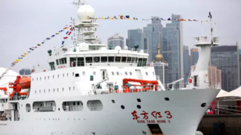
Research Vessels at the Center of the Effort
At the center of the effort are research vessels like the Dong Fang Hong 3, which has spent the past two years surveying waters near Taiwan, Guam, and key stretches of the Indian Ocean. Officially described as scientific missions, these voyages have involved detailed seabed mapping and monitoring activities that analysts say have clear military applications.
While Chinese institutions describe the work as climate research and resource surveys, experts cited by Reuters say the scale and focus of the effort point to a dual-use strategy combining civilian science with defense objectives.

Mapping the Seabed, Tracking the Battlespace
Data reviewed by Reuters shows that Chinese vessels have been systematically mapping the ocean floor by traveling in tight, repeated patterns across large areas, a standard method for seabed surveys. At least eight ships have conducted such mapping, while others carry specialized equipment for similar work.
"The vessels' survey data would be potentially invaluable in preparation of the battlespace," said Peter Scott, a former chief of Australia's submarine force. "Any military submariner worth his salt will put a great deal of effort into understanding the environment he's operating in."
The surveys have focused on strategically important areas, including waters near the Philippines, Guam, Hawaii, and key US-linked military locations in the Pacific.
'Civil-Military Fusion' at Work
Analysts say the program reflects China's broader policy of integrating civilian research with military capability, often referred to as "civil-military fusion." Jennifer Parker, a defense expert at the University of Western Australia, said the scale of the activity suggests long-term strategic intent.
"If you look at the sheer extent of it, it's very clear that they intend to have an expeditionary blue-water naval capability that also is built around submarine operations," she said.
China's ministries did not respond to Reuters' queries, while the US defense department also declined comment. However, Rear Admiral Mike Brookes of the US Office of Naval Intelligence told a congressional panel that such data "enables submarine navigation, concealment, and positioning of seabed sensors or weapons," adding that it represents a "strategic concern."
Why Seabed Data Matters
Experts say detailed knowledge of underwater terrain, temperature, salinity, and currents is critical for both deploying submarines and detecting them. Sound waves used in sonar systems behave differently depending on ocean conditions, making such data essential for underwater operations.
Tom Shugart, a former US submarine commander, noted that sonar effectiveness depends heavily on environmental factors, while Parker added that such information helps submarines avoid detection and operate safely.
China's mapping efforts are particularly concentrated around the "First Island Chain" – a strategic arc of territories stretching from Japan through Taiwan to Southeast Asia. "They're paranoid about being boxed into the First Island Chain," said Peter Leavy, a former Australian naval attaché.
Expanding Reach from Pacific to Indian Ocean
China's surveys extend beyond the Pacific. Data shows extensive mapping in the Indian Ocean, including routes near the Malacca Strait, a critical chokepoint for global trade and Chinese energy imports.
"China has some key vulnerabilities when it comes to dependencies on maritime trade," Parker said, adding that the surveys indicate an increase in submarine operations in the region.
Chinese vessels have also mapped waters near Alaska and into the Arctic, aligning with Beijing's stated ambition to become a "polar great power" by the 2030s.

The 'Transparent Ocean' Vision
A key component of China's strategy is the development of a "transparent ocean," a network of sensors, buoys, and subsea systems designed to monitor ocean conditions in real time.
Proposed in 2014 by scientist Wu Lixin, the project has expanded from the South China Sea to the Pacific and Indian oceans, with hundreds of sensors deployed in key maritime zones. These systems track temperature, salinity, and subsea movement, data that can support both scientific research and military surveillance.
US officials say such networks could enable persistent monitoring of submarine activity. Brookes noted they help "optimize sonar performance and enable persistent surveillance of submarines transiting critical waterways."
Strategic Implications and Concerns
The scale of China's ocean mapping effort has raised concerns among defense analysts about shifting maritime balances.
"For decades, the US Navy could assume an asymmetric advantage in its knowledge of the ocean battlespace," said Ryan Martinson of the US Naval War College. China's efforts "threaten to erode that advantage."
Collin Koh, a maritime security expert in Singapore, said the program reflects China's expanding reach: "They now have a reasonably good picture of the maritime domain they hope to operate in, either in peacetime or in war."
As geopolitical competition intensifies, experts say control over undersea data, often less visible than surface military build-ups, could play a decisive role in future naval operations.