Chandigarh Administration to Launch Naksha Survey in Five Villages
The Chandigarh administration has announced plans to conduct a detailed Naksha survey of land properties in five villages within the union territory. This initiative aims to update and digitize land records, ensuring accurate documentation and reducing legal disputes over property ownership.
Scope and Objectives of the Survey
The survey will cover villages including Kishangarh, Daria, Mauli Jagran, Behlana, and Khuda Alisher. Officials will map out land boundaries, verify ownership details, and assess property usage. This effort is part of a broader strategy to modernize land management systems and support sustainable urban development in Chandigarh.
By creating precise digital maps, the administration hopes to streamline processes for property transactions, taxation, and infrastructure planning. The survey is expected to address long-standing issues related to encroachments and unauthorized constructions, promoting transparency in land administration.

Implementation and Timeline
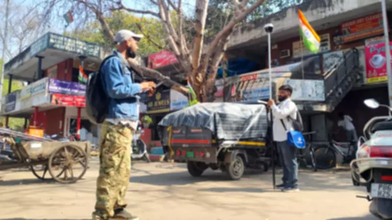
The Naksha survey will be carried out by the Revenue Department in collaboration with technical experts. Advanced tools such as GPS and GIS technology will be utilized to ensure high accuracy in measurements and data collection. Public awareness campaigns will be conducted to inform residents about the survey process and encourage their cooperation.
Authorities have indicated that the survey is scheduled to commence in the coming weeks, with completion targeted within a few months. This timeline may be adjusted based on field conditions and community feedback, but the administration is committed to expediting the project to benefit local stakeholders.
Benefits for Residents and Governance
For villagers, the updated Naksha records will provide legal clarity on property rights, potentially reducing litigation costs and conflicts. It will also facilitate access to government schemes and loans by providing verifiable land documents. From a governance perspective, the survey will enhance urban planning efforts, enabling better allocation of resources for amenities like roads, water supply, and sanitation.
This move aligns with national initiatives to digitize land records under the Digital India campaign, reflecting Chandigarh's proactive approach to leveraging technology for public service improvement. The administration plans to integrate the survey data with existing land databases for seamless access and updates in the future.