Major Infrastructure Boost: Centre Approves 100-km Access-Controlled NH-16 Corridor
In a significant infrastructure development that promises to transform regional connectivity, the Central government has given its approval for converting a crucial 100-kilometer stretch of National Highway 16 into a fully access-controlled corridor. This strategic upgrade aims to dramatically enhance high-speed connectivity and substantially reduce travel time between Vijayawada and Bangalore, marking a pivotal step in Andhra Pradesh's transportation modernization efforts.
Strategic Section and Integration Plans
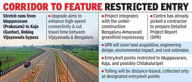
The approved section runs from Muppavaram near Addanki in Prakasam district to Kaja in Guntur district, effectively linking to the existing Vijayawada bypass. Government officials emphasize that this upgrade is particularly crucial for seamless integration with the under-construction Bengaluru–Amaravati greenfield expressway, while also providing faster and safer access to the capital region of Amaravati.
The project clearance came following a formal request from Andhra Pradesh Chief Minister Chandrababu Naidu during his recent visit to New Delhi, demonstrating the state government's proactive approach to infrastructure development. Authorities have already selected a contractor to prepare the Detailed Project Report, with Bhopal-based firm LN Malviya tasked with delivering this comprehensive assessment within one year.

Comprehensive Project Assessment Underway
The Detailed Project Report will encompass multiple critical aspects of the infrastructure upgrade, including:
- Land acquisition requirements and feasibility studies
- Detailed engineering design specifications
- Environmental impact assessment and mitigation measures
- Comprehensive cost estimates and financial projections
Although the existing stretch already functions as a six-lane highway, the absence of proper service roads has created persistent operational challenges. Local traffic currently merges directly onto the main carriageway, causing frequent disruptions and compromising both safety and traffic flow efficiency.
Transformative Infrastructure Features
Once upgraded to full access-controlled standards, the corridor will feature several transformative elements designed to optimize traffic management and enhance safety:
- Dedicated two-lane service roads constructed along both sides of the entire 100-kilometer length, enabling local vehicles to travel parallel without entering the high-speed main highway
- Complete elimination of direct access from villages, towns, or minor roads onto the main carriageway
- Restricted entry and exit points limited to strategic locations, primarily at Muppavaram (connecting to Amaravati Outer Ring Road) and near Kaja (at Vijayawada bypass junction)
- Potential additional access points at key locations like Chilakaluripet, subject to final planning decisions
- Implementation of distance-based toll collection exclusively at designated entry and exit points
Regional Connectivity and Economic Impact
This development is expected to create a seamless link with the ambitious 343-kilometer Bengaluru-Vijayawada economic corridor (NH-544G), which is currently under construction as a six-lane greenfield access-controlled highway from Kodur in Sri Sathya Sai district to Muppavaram. When both projects reach completion, the journey from Bengaluru to Amaravati could potentially be reduced to just 7–8 hours, representing a dramatic improvement over current travel times.
The enhanced connectivity is projected to deliver substantial economic benefits, including:
- Boosted economic activity across the region
- Improved logistics efficiency for businesses
- Enhanced trade facilitation between major economic centers
- Overall acceleration of regional development initiatives
Safety and Efficiency Advantages
Access-controlled highways, commonly referred to as expressways, prioritize safety and operational efficiency through several key design principles:

- Elimination of at-grade intersections that typically cause traffic conflicts
- Removal of pedestrian crossings along the main carriageway
- Prevention of random entries that disrupt traffic flow
- Complete rerouting of local traffic to parallel service roads
These features collectively contribute to significantly reduced accident risks and minimized congestion, creating a safer and more predictable travel environment for all road users.
Broader Strategic Context
The project forms an integral component of Andhra Pradesh's comprehensive strategy to modernize NH-16 and establish world-class road connectivity to the capital region, as well as major urban centers including Vijayawada and Guntur. Government officials anticipate that the Detailed Project Report will provide final clarity on land requirements and finalize the detailed engineering blueprint before construction tenders are formally floated, ensuring systematic and efficient project implementation.
This infrastructure initiative represents a forward-looking approach to transportation development, aligning with broader national objectives of enhancing inter-state connectivity and supporting regional economic growth through improved physical infrastructure networks.