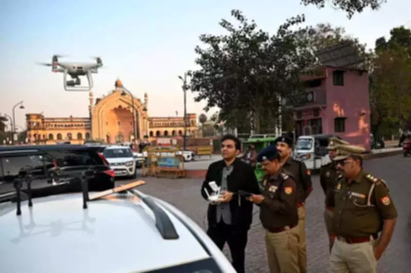
Lucknow Police Employs Drone Technology to Tackle Chinese Manjha Crisis
In a decisive technological move to address the escalating danger of deadly Chinese manjha, the Lucknow Police has initiated a drone-based surveillance program. This strategy focuses on detecting, geo-tagging, and monitoring kite-flying hotspots throughout the city, responding to recent tragic incidents.
Urgent Response to Fatal Incidents
The deployment was activated on Monday, following a week marked by severe injuries and a fatality. A pharmaceutical company sales manager lost his life, and numerous others sustained serious wounds after encounters with the razor-sharp kite strings. This prompted immediate action from law enforcement to prevent further harm.
Deputy Commissioner of Police (West Zone) Vishwajeet Srivastava detailed the plan, stating, "Since most kite flying occurs in the West Zone, we are utilizing drones to geo-tag locations. This allows us to dispatch ground teams to inspect the manjha used. We have already identified and geo-tagged approximately 20 such spots."

Overcoming Enforcement Challenges with Aerial Surveillance
Officials highlighted that drone surveillance effectively tackles a major enforcement hurdle: accessing rooftops and densely populated residential areas where kite flying is prevalent. By employing aerial imaging, drones can:
- Scan rooftops, terraces, and open spaces thoroughly.
- Identify individuals engaged in kite flying activities.
- Capture clear digital evidence of violations, including the use of prohibited synthetic or metal-coated manjha.
This approach ensures comprehensive monitoring without the limitations of ground-based operations.
Expert Insights on Drone and AI Integration
Milind Raj, a drone and AI technology expert who guided the Lucknow Police, explained the system's design. "These systems are tailored to aid law enforcement in detecting violations that are hard to spot from the ground. They combine hybrid imaging devices with a ground control station, specifically targeting those who flout the law," he remarked.
Advanced Drone Capabilities and Deployment Strategy
The unmanned aerial vehicles boast impressive specifications:
- A monitoring range exceeding 8,000 metres.
- Flight altitudes of 850 metres and above.
- Equipped with location-tagging systems and hybrid zoom cameras for precise tracking.
These features enable real-time relay of violator coordinates to ground teams, enhancing response efficiency. The police will deploy two drone types:
- A larger surveillance UAV for extended monitoring missions.
- A small, high-speed drone capable of reaching 80–100 kmph, allowing rapid deployment to identified hotspots within seconds.
Long-Term Benefits and Predictive Policing
The geo-tagging initiative is set to create a permanent database of frequent kite-flying zones. DCP Srivastava emphasized, "This database will facilitate predictive policing, enabling quicker raids and sustained monitoring, especially during festival seasons when kite flying peaks."
This proactive measure aims to not only address immediate threats but also establish a framework for ongoing safety and enforcement in Lucknow.