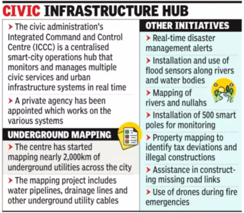
The Integrated Command and Control Centre (ICCC) of the Pune Municipal Corporation (PMC), situated in the Sinhagad Road area, has initiated a comprehensive mapping of nearly 2,000 kilometers of underground utilities. This includes water pipelines, drainage lines, and various cables, aiming to provide precise data for effective planning, maintenance, and repair operations.
Progress and Benefits of Utility Mapping
Out of the total utilities to be mapped, approximately 600 kilometers along key road stretches across the city have already been surveyed using advanced software systems. The remaining work is projected to be completed within the current fiscal year. This mapping exercise has successfully identified nearly 120 locations where sewage lines are likely to come into contact with water pipelines, as well as several flood-prone spots. PMC officials highlighted that since consolidated data on underground utilities was previously unavailable, this project will be invaluable for future planning and infrastructure management.
Disaster Management Enhancements
The ICCC is also focusing on strengthening disaster management by adopting advanced software and modern systems. Recently, the centre deployed drones to assist in handling fire emergencies. These drones were utilized at the PMC fire department's Katraj fire station to provide real-time information about the nature of fires and the equipment required to tackle them effectively. Officials have announced plans to introduce drones at other fire stations in a phased manner. In another initiative, the ICCC is developing advanced software to help identify illegal properties and unauthorized constructions.

Madhav Jagtap, head of PMC's disaster management department, stated, "The ICCC is working on multiple technology platforms and plans to integrate advanced systems into the PMC's daily operations and data management processes."

Key Initiatives of the Integrated Command and Control Centre
- Real-time disaster management alerts
- Installation and use of flood sensors along rivers and water bodies
- Mapping of rivers and nullahs
- Installation of 500 smart poles for monitoring
- Mapping of underground utilities
- Property mapping to identify tax deviations and illegal constructions
- Assistance in constructing missing road links
- Use of drones during fire emergencies
- Traffic monitoring under the Advanced Traffic Management System (ATMS)
- Monitoring the movement of garbage vehicles