Telangana Government Initiates Major Land Survey to Resolve Village Disputes
The Telangana state government is embarking on a significant initiative to tackle long-standing land disputes and the absence of reliable village maps by launching a large-scale scientific land survey. This comprehensive exercise will cover 373 villages across 25 districts, utilizing advanced technology to create precise digital land records and clearly map land boundaries.
Advanced Technology Deployment for Accurate Mapping
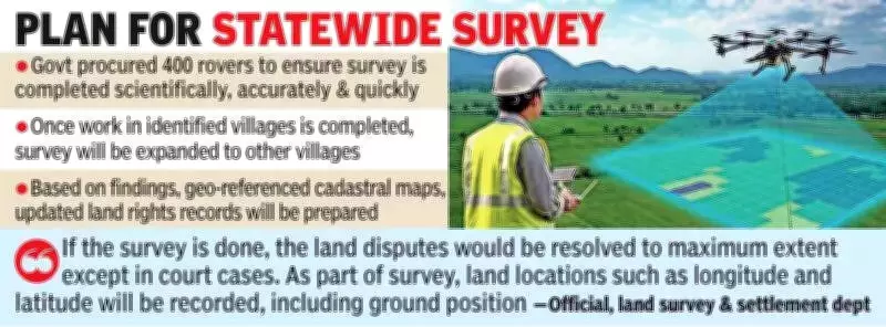
For this ambitious project, the government has already procured approximately 400 rovers to ensure the survey is conducted scientifically, accurately, and efficiently. The initiative will employ cutting-edge methods, including rover-based and drone-based surveys, to capture detailed geographical data. Once completed in the initial villages, the survey will be expanded to other villages across the state in a phased manner.
Pilot Project Paves the Way for Larger Rollout
Before implementing the statewide exercise, the government conducted a pilot project in five key villages: Salarnagar in Gandid mandal (Mahbubnagar district), Kommanapally in Bheerpur mandal (Jagtial district), Mulugumada in Errupalem mandal (Khammam district), Nuguru in Venkatapuram mandal (Mulugu district), and Shahidnagar in Vatpally mandal (Sangareddy district). Based on the successful outcomes, the government decided to prioritize villages lacking proper village maps, which are essential for documenting survey numbers, topography, land extent, and other critical information.

Overcoming Challenges in Implementation
The government initially planned a comprehensive land survey across the entire state in one go, as mentioned in the Bhu Bharati Act. However, the process has faced delays due to two major challenges, aside from budget constraints: a shortage of licensed surveyors and limited availability of rovers. To address this, Revenue Minister Ponguleti Srinivas Reddy recently announced plans to procure an additional 400 rovers, with budget allocation proposals expected in the upcoming state budget.
Expected Outcomes and Future Plans
A senior official from the land survey and settlement department highlighted that the survey aims to resolve land disputes to the maximum extent, except for ongoing court cases. The process will record land locations, including longitude and latitude, along with ground positions. Officials explained that the survey will combine two methods: aerial drone surveys and ground-truthing surveys. The findings will be used to prepare geo-referenced cadastral maps and updated land rights records.
After completing the survey in the 373 villages, the government is likely to appoint a consultant to develop detailed proposals for a comprehensive statewide survey. A senior revenue official noted that the government will explore various central government schemes to secure financial assistance for this extensive project.