For centuries, dense jungle growth has not only been a geographical feature but also a protective shroud for the remains of ancient cities, concealing their streets, terraces, platforms, and structures. However, modern technologies, particularly airborne remote-sensing methods known as LiDAR, are now enabling archaeologists to uncover old city grids that were previously inaccessible from the ground due to thick forestation.
How LiDAR Works
LiDAR, which stands for Light Detection and Ranging, operates by sending pulses of light toward the Earth's surface from the sky. While many pulses are reflected by branches and leaves, some manage to pass through gaps in the foliage and reach the ground. The reflected signals from these pulses are then used to create detailed digital models of the Earth's surface, effectively removing the forest cover from the imagery. According to NASA Earth Observatory, this technique allows scientists to gather information that would be extremely challenging to obtain on foot, as it is hidden beneath dense forest canopies. Moreover, LiDAR has become essential in archaeology because it can precisely map large areas without disturbing the vegetation.
Seeing Cities Beneath the Trees
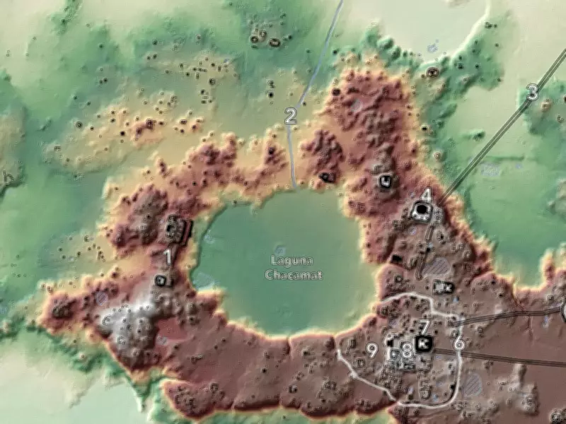
The significance of LiDAR extends beyond its ability to locate remote sites; it reveals patterns that were previously invisible. Strong geometric lines and shapes, repetitive platforms, and other indicators of planned and organized civilizations suddenly emerge from the data. A 2022 article in Nature described how LiDAR surveys were used to map extensive settlement systems of the Maya world. These surveys uncovered large-scale, organized networks of cities and communities in tropical forests, including causeways, terraces, and residential districts that spanned entire landscapes. This explains the striking images of a buried city grid emerging from the jungle canopy—not a new construction, but an ancient city that had been hidden under tropical growth all along.

Today, remote sensing is a common practice in archaeology, unlike earlier years when it was still experimental. LiDAR, multispectral imagery, and synthetic aperture radar (SAR) have become standard non-invasive approaches for locating buried archaeological artifacts.
Why the Discoveries Matter
The revelation of urban grids within forests is important not only for the stunning images produced by the scans but also because these discoveries reshape historical interpretations of ancient civilizations. A grid layout can indicate how transportation, farming, and urban settlements were organized on a regional level. Roadways, terraces, and compound complexes offer insights into labor systems and planning processes that would be difficult to determine otherwise. For instance, studies of Maya civilizations using LiDAR have demonstrated that ancient societies may have had even larger networks of urban landscapes than previously believed. These findings allow scholars to reevaluate their view of these cities beyond monumental architecture and consider them in a broader context.
However, archaeologists caution that LiDAR does not provide instant conclusions. While digital elevation models may show features such as roads, terraces, or platforms, these must be verified through field surveys to confirm their archaeological significance.