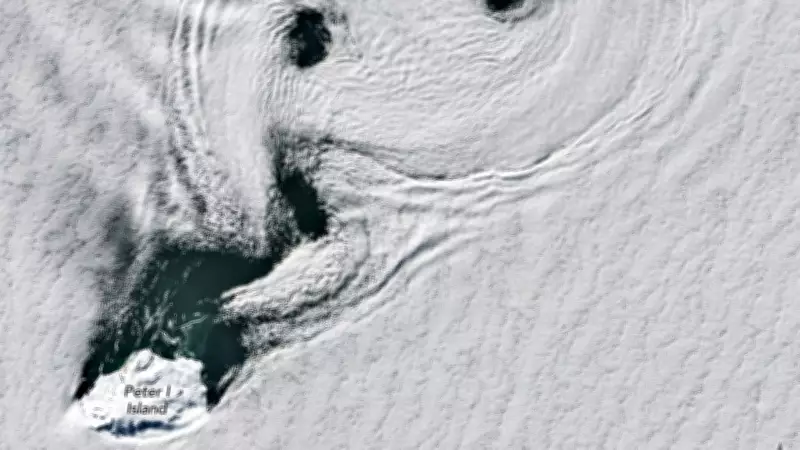
NASA has released an extraordinary aerial photograph captured by its Earth Observatory site, showcasing a spectacular 'sea of rotating clouds' near Antarctica. The image, taken by the Landsat 8 satellite over Peter I Island in the Bellingshausen Sea, reveals a rare atmospheric phenomenon known as Von Kármán vortex streets. These spinning clouds formed due to fierce winds interacting with the island's terrain, creating a mesmerizing pattern of counterrotating spirals that stretch across the frozen seas.
What Are the Spinning Clouds Seen by NASA?
These cloud formations are the result of an atmospheric process called the von Kármán vortex street effect. This occurs when airflow hits obstacles such as mountains or islands, causing the air to deflect, slow down, and spin into eddies. According to NASA's Earth Observatory, the pattern formed behind Peter I Island, a volcanic island off the west coast of Antarctica. The image was captured by the Operational Land Imager on the Landsat 8 spacecraft on February 11, 2026.
Peter I Island and Antarctica's Extreme Winds
The unique cloud formation emerged near Peter I Island, a remote volcano in the Southern Ocean known for its extreme winds. Sailors have historically referred to these latitudes as the 'Roaring Forties,' 'Furious Fifties,' and 'Screaming Sixties.' NASA explains that winds in this region travel relatively unimpeded by land, allowing atmospheric events to form clearly over water. However, experts note that winds must remain within certain speed limits for the vortices to maintain their shape; excessive speeds can cause the vortex structure to collapse.

Why Von Kármán Vortex Streets Matter in Science
Beyond their visual appeal, these clouds provide valuable scientific insights into atmospheric processes. Von Kármán vortices help scientists study atmospheric flows, turbulence, and meteorology, even in extraterrestrial environments. The phenomenon is named after physicist Theodore von Kármán, who researched fluid dynamics around objects moving through air. NASA's observations of these vortices contribute to research on Antarctica's climate, including studies conducted during Operation IceBridge, which measured ice coverage in polar regions between satellite campaigns.
How Satellite Imagery Helps Scientists Understand Earth
Satellites like Landsat 8 allow researchers to observe weather and climatic conditions from space with remarkable accuracy. These images are not only visually striking but also crucial for monitoring environmental changes. Scientists use satellite pictures to develop better climate models, track wind currents, and understand how remote regions respond to atmospheric changes. In remote areas like Antarctica, where direct measurements are difficult, satellite imagery is especially valuable.
A Breathtaking Reminder of Earth's Natural Patterns
The 'ocean of swirling clouds' captured by NASA is more than just a stunning image from space. It illustrates that Earth's atmosphere is never static, constantly creating amazing patterns invisible from the ground. The cloud formations over Antarctica's ice-covered continent and the stormy Southern Ocean showcase the beauty of nature's laws in action. They also serve as proof that satellite science continues to uncover remarkable discoveries about our planet.
About the Author: The TOI Science Desk is a team of inquisitive journalists dedicated to curating captivating science news, features, and articles for readers of The Times of India. They strive to make science accessible and engaging, covering topics from genetic engineering to space exploration and artificial intelligence.