India's NavIC & NVS Satellites: PNT Constellation Explained for Strategic Autonomy
In the realm of global navigation and strategic independence, India has made significant strides with its own Positioning, Navigation, and Timing (PNT) constellation. This network of satellites, including the NavIC (Navigation with Indian Constellation) and NVS (Navigation with Indian Satellite System) satellites, is reshaping how the country approaches geopolitics, governance, and even competitive exams.
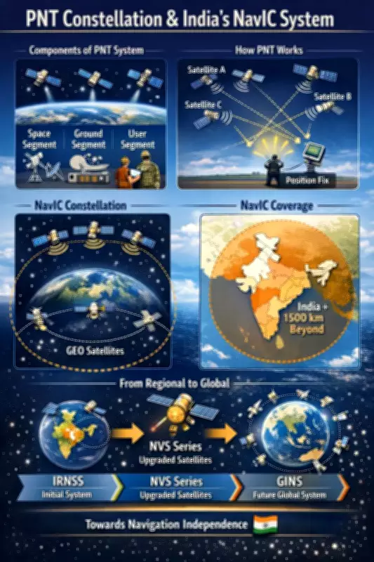
What is a PNT Constellation?
A PNT constellation refers to a sophisticated network of satellites orbiting Earth that deliver precise data to users on the ground. This system provides three critical types of information:
- Position: Exact location coordinates, enabling accurate mapping and tracking.
- Navigation: Real-time movement and velocity data, essential for transportation and logistics.
- Timing: Highly accurate time synchronization, crucial for telecommunications, financial transactions, and scientific research.
These capabilities are fundamental not just for everyday applications but also for national security and economic resilience.

India's NavIC and NVS Satellites: A Strategic Leap
India's foray into this domain is marked by the NavIC system, which initially comprised a constellation of satellites designed to provide regional coverage over India and surrounding areas. The recent introduction of NVS satellites represents an upgrade, enhancing the system's accuracy, reliability, and global reach.
This development is a cornerstone of India's strategic autonomy in navigation, reducing dependence on foreign systems like the American GPS, Russian GLONASS, or European Galileo. By controlling its own PNT infrastructure, India gains:
- Geopolitical Leverage: In an era where navigation systems are tools of power, having an indigenous system allows India to assert its sovereignty and influence in international affairs.
- Enhanced Governance: From disaster management to urban planning, precise PNT data improves public service delivery and policy implementation.
- Economic Benefits: Industries such as agriculture, aviation, and maritime trade benefit from reliable navigation, boosting productivity and safety.
Impact on Exams and Daily Life
Beyond high-stakes geopolitics, the PNT constellation has practical implications. For instance, in competitive exams like the UPSC, questions on NavIC and satellite technology are increasingly common, reflecting their importance in national development. Moreover, everyday applications include:
- Smartphone navigation apps using NavIC for better accuracy in remote areas.
- Time synchronization for networks, ensuring seamless communication.
- Support for autonomous vehicles and drones, paving the way for future innovations.
As India continues to expand its PNT capabilities with advanced NVS satellites, the focus remains on achieving full strategic autonomy. This not only safeguards national interests but also positions India as a key player in the global navigation landscape, influencing everything from military operations to civilian advancements.