Perched on a wind-lashed hill at Kalyanpur village near Sironj in central Madhya Pradesh, about 100 kilometers northeast of Bhopal in Vidisha district, Bhuri Tori once pulsed like the geodetic heart of undivided India. From this rocky outpost, British surveyors fixed coordinates, tracked stars, and stitched together one of history's most audacious scientific enterprises: the Great Trigonometrical Survey (GTS).
Origin of the Name
The name Bhuri Tori derives from local observations. "Bhuri" referred to fair-skinned foreigners, while "Tori" meant restless bustle. British surveyors mapped a continent from this ridge, and from here came numbers that measured the world's tallest mountain. Mount Everest entered history, but Bhuri Tori slipped out of it. The name lingered while the science faded. Today, thieves measure stones here.
Historical Significance
Survey of India records show that the then Surveyor General Colonel George Everest adopted Kalyanpur's trigonometrical station in 1840 as an "origin of calculation" for the GTS. This colossal 19th-century project mapped territories stretching across present-day India, Pakistan, Bangladesh, Afghanistan, Myanmar, and Sri Lanka with mathematical precision unprecedented for its age. Long before satellites and GPS, surveyors built chains of triangles across jungles, deserts, and mountains. One measured baseline, paired with angles and trigonometry, unlocked distances across thousands of kilometers.

Begun by William Lambton in the early 1800s and later expanded by Everest, Andrew Scott Waugh, and James Walker, the GTS transformed cartography and geodesy. Mathematician Radhanath Sikdar later computed the height of Mount Everest in the 1850s using survey data generated through this sprawling scientific grid. Bhuri Tori sat near its intellectual center of gravity.
Scientific Operations
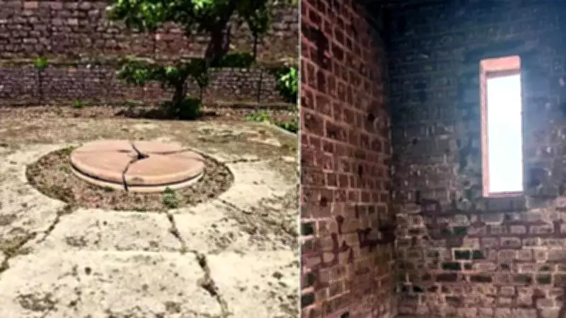
Historical accounts describe nearly 700 workers camped on the hill for close to two years, alongside four elephants, 42 camels, and 30 horses, while observatory structures rose from black stones. The structure still hints at the scientific choreography once performed here. The roofless black stone enclosure contains recesses in north-south walls, designed for astronomical observations. Open sky functioned as the laboratory ceiling. Gas lanterns flashed signals toward telescopes mounted on pillars in nearby Surantal village for triangulation checks. Two pendulum-driven structures were later added nearby. Now, only hollow shells remain.
Current State of Decay
Today, stones have been pried loose. Walls stand scarred. Pendulums have vanished. Black stone observatories lie gutted under open skies where astronomers once mapped a continent and made calculations linked to measuring Mount Everest's height. History survives here in fragments. Chunks of masonry have disappeared. Weather gnaws at exposed stone. Heritage watchers say vandalism and theft have hollowed out the site faster than authorities acknowledge it.
Pages of the 1917 volume "Triangulation in India and Adjacent Countries" place Bhuri Tori within the wider geodetic framework underpinning surveys across South Asia. Coordinates fixed from this ridge rippled outwards through maps, military charts, and administrative boundaries for decades. Now, entropy has taken over.
Official Neglect
Sironj sits roughly two hours by road from Bhopal. Yet Bhuri Tori remains largely absent from tourism circuits and conservation plans. Sironj Chief Municipal Officer Ramprakash said the matter falls outside urban body jurisdiction because the site lies under village panchayat limits. Silence hangs heavier on a hilltop than bureaucracy below. "As it is an archaeological matter, only the agencies related to that can answer," said Vidisha Collector Anshul Gupta when asked about preservation efforts.
Local history enthusiast Shoaib Gazi, who promotes the site through social media, described Bhuri Tori as "our hidden hero, reduced to complete neglect." He said Everest selected Kalyanpur because it occupied a strategic midpoint between Great Arc measurements and Prime Meridian calculations. "It was perfectly placed to split the longitudinal gap between the Great Arc and Prime Meridian," he added.

A Stubborn Question
As India hurtles deeper into the age of satellites and remote sensing, Bhuri Tori poses a stubborn question: can a nation preserve landmarks that first taught it how to measure itself? The site, once the geodetic heart of a continent, now lies forgotten, its stones stolen and its history fading. Without intervention, this monument to scientific achievement may soon be lost entirely.