Scientists have unveiled the most detailed map ever created of the terrain hidden beneath Antarctica's massive ice sheet. This groundbreaking research reveals a dramatic landscape of mountains, deep canyons, wide valleys, and tens of thousands of previously unknown hills.
Mapping the Hidden Continent
Researchers used advanced satellite data and innovative ice-flow modeling techniques to create this comprehensive map. They employed a method called ice-flow perturbation analysis, which estimates what lies beneath the ice by studying surface features. This approach allowed them to map the entire continent, including areas that were previously uncharted.
The new map shows Antarctica's bedrock with unprecedented precision. For the first time, scientists have identified more than 30,000 hills that were completely unknown before. These hills are defined as terrain protuberances rising at least 165 feet above their surroundings.

Why This Matters for Climate Predictions
Understanding Antarctica's hidden landscape is crucial for predicting how quickly the continent's ice will melt. The shape of the bedrock beneath the ice creates friction that affects ice flow. This friction must be included in numerical models that project Antarctica's contribution to global sea-level rise.
"Having the most accurate map of Antarctica's bed shape is absolutely crucial," said glaciologist Robert Bingham of the University of Edinburgh, who helped lead the study. "The shape of the bed controls friction against ice flow, which we need to include in models that project how rapidly Antarctica's ice will flow toward the ocean."
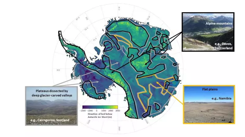
A Landscape of Extremes
Antarctica is a continent of dramatic proportions. It is about 40% larger than Europe, 50% larger than the United States, and roughly half the area of Africa. The newly revealed landscape contains the same variety of features found on other continents.
"In every case, all of these continents contain an array of very different landscapes," Bingham explained. "From towering mountain ranges to immense flat plains. The hidden landscape of Antarctica also contains these vast extremes. Boring it is not."
The Antarctic Ice Sheet represents the largest mass of ice on Earth. It holds about 70% of the planet's freshwater. The ice averages about 1.3 miles thick, with some areas reaching nearly 3 miles deep.
Historical Context and Geological Significance
Antarctica has not always been covered in ice. The subglacial features were initially sculpted before the continent acquired its icy covering more than 34 million years ago. The dynamic ice sheet has further modified these features over time.
Antarctica was once connected to South America but separated due to plate tectonics. This gradual movement of continent-sized plates created the isolated continent we know today.
The new map reveals landscapes that resemble regions in Scotland, Scandinavia, northern Canada, and Greenland. "The very fact that the landscape our technique has uncovered across Antarctica matches these landscapes so well gives us great confidence in our new map," Bingham noted.
Advancements in Mapping Technology
Until now, the surface of Mars was better mapped than the terrain beneath Antarctica's ice. Traditional methods involved radar equipment suspended on planes or towed by snowmobiles. These surveys often left significant gaps between measurements.
"These surveys often have gaps of 5 kilometers or 10 kilometers between them," explained glaciologist Helen Ockenden, lead author of the study. "Sometimes the gaps reach up to 150 kilometers."
The new method represents a significant advancement. "It allows us to combine the mathematics of how the ice flows with high-resolution satellite observations," Ockenden said. "We can say what the landscape beneath the ice must look like everywhere across the whole continent, including in all those survey gaps. We really gain a much more complete idea of how all the landscape features connect together."
Practical Applications and Future Research
The researchers hope their map will improve models used to project future sea-level rise. It should also enhance forecasts issued by the Intergovernmental Panel on Climate Change, which provides governments with data to shape climate policies.

"We can now also identify better where Antarctica needs more detailed field survey, and where it does not," Bingham added. This targeted approach will make future research more efficient and effective.
The study represents a major step forward in understanding our planet's last unexplored continent. As climate change accelerates, this detailed knowledge of Antarctica's hidden terrain becomes increasingly important for predicting global environmental changes.