NASA Satellite Reveals Ancient Canadian Glacier's Climate Change Story
A stunning photograph captured from high above Earth tells a profound story that can only be fully appreciated from a celestial vantage point. This remarkable image showcases a small, picturesque lake nestled against the edge of one of Canada's oldest ice formations, presenting a scene of apparent tranquility that masks a deeper environmental narrative.
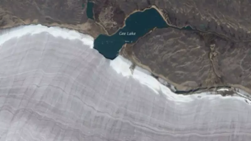
Rare View of Gee Lake and the Barnes Ice Cap
This extraordinary photograph features Gee Lake bordering the Barnes Ice Cap on Baffin Island in northern Canada. The image was captured by NASA's Earth Observing-1 satellite in September 2010, providing a clear visual representation of the interaction between liquid water and ancient glacial ice. While the lake measures approximately 3.2 kilometers across, its significance lies in its unique geographical position, where it cuts into the glacier's perimeter edge.
According to NASA Earth Observatory observations, the glacier's surface displays characteristic ridges that resemble the natural growth lines of a clamshell. These distinctive formations have been created by moving meltwater flowing across the ice surface over time, giving the glacier its shell-like appearance when viewed from above.

Canada's Oldest Ice Mass and Its Ancient Origins
The Barnes Ice Cap represents an incredible geological treasure with a remarkable history. Scientific analysis of ice cores extracted from this glacier indicates that certain sections contain ice dating back approximately 20,000 years to the last Ice Age. What makes the Barnes Ice Cap particularly significant is its status as the sole surviving remnant of the massive Laurentide Ice Sheet that once covered much of North America and sculpted the continent's landscape during its expansive reign.
Scientific accounts document that this ancient glacier spans approximately 6,000 square kilometers and is considered a "last remnant" of a once vast frozen world that dominated the northern hemisphere. Essentially, the Barnes Ice Cap preserves ice that formed during the dawn of human civilization, offering scientists a frozen time capsule of Earth's climatic history.
What This Scene Reveals About Climate Change
Behind the picturesque beauty of this satellite image lies a serious environmental concern. The formation of meltwater lakes like Gee Lake around glacier perimeters is frequently attributed to rising global temperatures. Current observations indicate that the Barnes Ice Cap is steadily shrinking, receding several meters each year. Scientific projections suggest this melting phenomenon may intensify in coming decades, with some calculations indicating the ice cap could virtually disappear within a couple of centuries under current climate conditions.
The melting process carries significant ecological implications beyond mere aesthetic changes. Meltwater weakens the internal structure of glaciers, leading to accelerated degradation and contributing to global sea-level rise. The image of Gee Lake serves not only as a natural wonder but also as a symbolic representation of geological processes transforming our planet. This juxtaposition of water and ice reflects Earth's history dating back thousands of years to the peak of the last Ice Age.
Monitoring climate change and its impacts remains crucial, even in Earth's most remote regions where these environmental transformations are quietly unfolding. The satellite image provides visual evidence of how ancient geological formations are responding to contemporary climate patterns, offering scientists valuable data about our changing world.