
Satellite Mission Uncovers Hidden Tsunami Dynamics in Pacific Ocean
A groundbreaking study linked to a powerful magnitude 8.8 earthquake near Russia's Kamchatka Peninsula has provided unprecedented insights into how tsunamis initiate beneath the ocean surface. Published in the journal Science, this research leverages data from the SWOT satellite mission to detect subtle wave patterns forming close to the earthquake source, which occurred on 29 July 2025. These findings suggest that space-based observations could revolutionize our understanding of tsunami risks by filling critical gaps left by traditional monitoring systems.
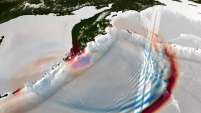
SWOT Satellite Captures Detailed Wave Patterns
Approximately 70 minutes after the earthquake, the SWOT satellite passed over the affected region and recorded the sea surface in two dimensions using its advanced radar system, capable of measuring height differences down to centimetres. The satellite not only detected the leading tsunami wave but also a sequence of trailing short-wavelength dispersive waves. Researchers from institutions including San Diego State University, Scripps Institution of Oceanography, DTU Space, and the Pontificia Universidad Católica de Valparaíso collaborated to analyze this data, reconstructing the wave field in intricate detail.
Near-Trench Slip and Its Implications
Earthquakes near subduction trenches, where one tectonic plate slides beneath another, exhibit unique behaviors. The study indicates that near-trench slip, detected indirectly through satellite observations, occurred at shallow depths of less than 10 kilometres beneath the seafloor. This area is notoriously difficult to monitor with land-based seismic networks due to their distance and sparse coverage across the ocean. The dispersive waves observed by SWOT pointed toward rupture in a specific section of the subduction zone, between 49.5°N and 52.5°N along strike, offering new clues about fault dynamics.

Limitations of Traditional Monitoring Systems
While traditional instruments like DART buoys remain vital for measuring pressure changes and tracking tsunami wave heights—in this event, one buoy recorded a crest-to-trough height of around 1.32 metres—they often struggle to capture finer wave structures. Shorter wavelength signals tend to weaken at depth, and the spacing between sensors leaves significant coverage gaps. In contrast, SWOT's wide-swath scanning enabled scientists to visualize patterns that would otherwise remain hidden, highlighting the need for integrated monitoring approaches.
Enhancing Hazard Planning and Forecasting
The detailed wave patterns revealed by SWOT carry important implications for hazard planning. Experts, including Ignacio Sepúlveda and Alice Gabriel, note that these dispersive waves help refine models of tsunami generation, leading to more accurate simulations and improved forecasting tools. Bjarke Nilsson, who contributed to data processing, emphasizes that integrating satellite inputs into modeling frameworks could support future risk assessments, potentially enhancing warning systems and public safety measures in tsunami-prone regions.
This study underscores the transformative potential of satellite technology in advancing our understanding of seismic and oceanic processes, paving the way for more resilient communities in the face of natural disasters.


