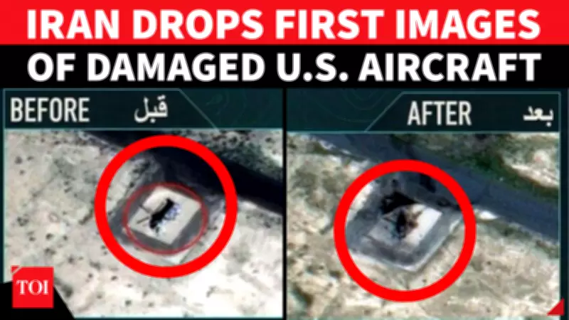
Iran Publishes Unseen Satellite Images of Damaged US Military Assets in Gulf
Freshly released satellite imagery from Iran has provided unprecedented visual evidence of the impact of recent strikes on United States military infrastructure in the Gulf region. The newly surfaced images, which have begun to reshape the understanding of the ongoing conflict, show clear and visible damage to key American assets at two critical operational hubs.
Detailed Damage to Critical US Helicopters Revealed
The imagery specifically highlights significant damage to a CH-47 Chinook heavy-lift helicopter stationed at Camp Buehring in Kuwait, as well as a CH-53 Sea Stallion helicopter located at Ali Al Salem Air Base, also in Kuwait. These facilities are not minor or peripheral installations; rather, they serve as central nerve centers for US military operations across the Middle East.
Camp Buehring and Ali Al Salem Air Base are fundamental to logistics coordination, troop deployment movements, and comprehensive air operations in the region. The impairment of these heavy-lift helicopters directly compromises battlefield mobility and strategic flexibility, limiting the US military's capacity to transport personnel, move essential equipment, and execute rapid response maneuvers across multiple operational theatres.

Strategic Implications for US Operations in the Region
The visible damage to these assets underscores a tangible degradation of US operational capabilities in a highly volatile area. The CH-47 Chinook and CH-53 Sea Stallion are workhorses of military logistics, designed for transporting heavy loads and troops in challenging environments. Their compromised status could force a reassessment of supply chains, mission planning, and force projection strategies.
This development arrives amid heightened tensions and a series of diplomatic failures, as reported in related coverage. The imagery release appears to be a calculated move by Iran, potentially aimed at demonstrating the effectiveness of its strike capabilities and influencing the geopolitical narrative surrounding the conflict.
The broader context includes reports of stalled talks, military posturing, and warnings, suggesting that the conflict's dynamics are intensifying. The damage evidenced in these satellite photos provides a concrete, visual dimension to what has largely been a war of statements and threats, marking a significant escalation in the information warfare aspect of the confrontation.