
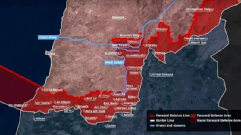
Israeli Military Publishes Comprehensive Map of South Lebanon Territory Under Its Control
The Israeli military has taken a notable step by publicly releasing a detailed and comprehensive map that delineates the specific territories in South Lebanon currently under its operational and administrative control. This move represents a significant development in the ongoing geopolitical dynamics of the region, providing unprecedented clarity on the extent of Israeli military presence in Lebanese territory.
Unveiling the Territorial Map
The newly published map offers a precise visual representation of the areas where Israeli forces maintain control, including key strategic locations and border zones. According to military sources, the map was created to enhance transparency and inform both domestic and international audiences about the current situation on the ground. It highlights various sectors, such as security checkpoints, patrol routes, and controlled access points, which are critical for maintaining stability in the region.
This publication comes amid heightened tensions and frequent skirmishes between Israeli forces and Lebanese militant groups, particularly Hezbollah. The map serves as an official acknowledgment of the Israeli military's footprint in South Lebanon, which has been a contentious issue for decades. Analysts suggest that this move could be aimed at reinforcing Israel's strategic position and deterring further incursions or attacks from Lebanese soil.

Regional Implications and Reactions
The release of the map has sparked a range of reactions from regional stakeholders. Lebanese officials have expressed strong disapproval, labeling the publication as a provocative act that undermines Lebanese sovereignty and violates international law. They argue that it legitimizes what they consider an illegal occupation of Lebanese land.
Conversely, Israeli authorities defend the action, stating that it is necessary for security purposes and to ensure the safety of Israeli citizens living near the border. "This map is a tool for clarity and accountability in a volatile region," an Israeli military spokesperson commented. "It reflects our commitment to protecting our borders while being transparent about our operations."
International observers are closely monitoring the situation, as this development could influence diplomatic efforts and peace negotiations in the Middle East. The United Nations and other global bodies have called for restraint and dialogue to prevent an escalation of hostilities.
Historical Context and Future Outlook
The Israeli-Lebanese border has been a flashpoint for conflict for many years, with South Lebanon often at the center of military engagements. The publication of this map adds a new layer to the complex history of territorial disputes in the area. It underscores the ongoing challenges in achieving a lasting peace and the difficulties in demarcating clear boundaries in a region fraught with historical grievances.
Looking ahead, experts predict that this move may lead to increased diplomatic tensions and potentially more frequent military confrontations. However, it could also pave the way for more structured discussions on border security and territorial rights. The international community is urged to engage proactively to mediate and find a peaceful resolution to the longstanding issues between Israel and Lebanon.
In summary, the Israeli military's publication of a map detailing its control over South Lebanon territory marks a pivotal moment in regional affairs. It highlights the persistent security concerns and territorial ambitions that continue to shape the Middle East's geopolitical landscape.


