Arctic Air Mass Unleashes Dangerous Winter Conditions Across United States
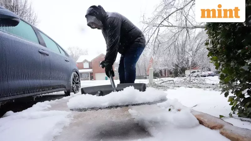
A formidable Arctic air mass is currently driving perilous winter weather across a vast portion of the United States. This system is responsible for generating lake-effect snow around the Great Lakes, triggering blizzard warnings in Alaska, and ushering in extreme cold to the Mid-Atlantic region. Forecasters are also monitoring the potential for another storm system to develop later in the week, which could exacerbate the already challenging conditions.
School Disruptions in Indiana and North Texas Amid Safety Concerns
On Wednesday, numerous schools in Indiana and North Texas remained closed or operated on delayed schedules. Authorities cited dangerous wind chills, icy roadways, and overarching safety concerns as the primary reasons for these disruptions. This occurred even as weather conditions showed gradual improvement in certain parts of Texas, highlighting the lingering impacts of the severe cold snap.
Great Lakes Region Battles Persistent Lake-Effect Snow
The National Weather Service Weather Prediction Center (WPC) has indicated that cold air sweeping across the Great Lakes is producing persistent lake-effect snow, expected to continue through Friday. In New York, a lake-effect snow warning remains active for Oswego, Jefferson, Lewis, and northern Cayuga counties until Thursday evening. Cities such as Oswego, Watertown, Lowville, and Fair Haven could witness accumulations of 1 to 2 feet of snow within the most persistent bands. Rapidly changing visibility conditions are making travel particularly hazardous in these areas.
Meanwhile, in Michigan, a flood advisory is in effect for Newaygo County. The National Weather Service Grand Rapids office reported that an ice jam on the Muskegon River is causing fluctuating water levels, posing an additional risk to residents.
Northern and Central Plains Experience Upslope Snow
High pressure moving southward from central Canada is generating upslope snow across the Northern and Central Plains from Wednesday through Friday, according to the WPC. This weather pattern adds to the winter precipitation affecting the central part of the nation.
Pacific Northwest and Rockies See Coastal Rain and Mountain Snow
An onshore Pacific flow is bringing coastal rain and mountain snow to the Pacific Northwest. Light snow is also spreading across the Northern Intermountain Region and the Northern Rockies. A winter weather advisory remains in effect across North Idaho and parts of eastern and southeastern Washington, including Spokane, Coeur d’Alene, Pullman, Moscow, Sandpoint, and Colville. Forecasters have warned of light snow, freezing rain, and slick roads, especially across the Palouse and Columbia Basin regions.
Alaska Faces Blizzard Conditions and Marine Hazards
In Alaska, a winter storm warning is active for the Dalton Highway Summits, encompassing areas like Finger Mountain, Prospect Creek, Gobblers Knob, and the Yukon River Bridge. Winds could gust up to 60 mph, reducing visibility to near zero in blowing snow, creating blizzard-like conditions. Marine conditions are equally hazardous, with the National Weather Service Anchorage issuing heavy freezing spray warnings for waters near Port Heiden, Nelson Lagoon, Bristol Bay, the Alaska Peninsula, and the Bering Sea. These conditions pose significant risks to maritime vessels operating in these areas.
Mid-Atlantic Endures Extreme Cold Warning
An extreme cold warning remains in effect for Western Highland County in Virginia and Grant and Pendleton counties in West Virginia until Thursday morning. Wind chills could plunge to 25 degrees below zero, significantly raising the risks of frostbite, hypothermia, and frozen pipes for residents in these regions.
South and Southeast Under Storm Watch
Forecasters are closely monitoring a developing system along the Gulf Coast. This system has the potential to bring rain and wintry precipitation from Louisiana and Mississippi to Alabama, Georgia, and the Carolinas later this week. Paul Pastelok, an AccuWeather long-range expert, stated, "Late this week, a storm is expected to strengthen along a stalled front near the Gulf Coast." Rain is most likely south of Interstate 10 from Louisiana to Florida, with a wintry mix possible farther north. AccuWeather noted that if the storm strengthens quickly, it could track northward and evolve into a nor’easter, increasing snow and coastal flooding risks from North Carolina to New England.
Cold Spell Expected to Persist Into February
Another surge of Arctic air is anticipated to follow the current system, keeping temperatures well below average into early February. Subfreezing temperatures could extend as far south as central Florida, threatening valuable citrus crops, as highlighted by Pastelok. This renewed cold wave arrives just days after a massive winter storm affected Texas, New York City, and over three dozen states. According to The Associated Press, that previous storm left more than 1 million customers without power and contributed to over 40 storm-related deaths.
Detailed Impact on Schools in Indiana and North Texas
Schools and businesses across parts of the United States remained closed or delayed on Wednesday as extreme cold and lingering winter storm impacts continued to disrupt normal operations. In central Indiana, an Extreme Cold Warning took effect late Tuesday, with wind chills expected to drop as low as minus 25 degrees. This warning follows a major winter storm that left much of the region buried under nearly a foot of snow. Indianapolis Public Schools announced a two-hour delay, with officials stating they would decide Wednesday morning whether to switch to a synchronous e-learning day based on temperatures and wind chills.
In North Texas, several school districts remained closed despite improving ice conditions. Major districts such as Dallas ISD and Fort Worth ISD canceled classes for Wednesday, while others continued to assess road conditions, weather forecasts, and campus safety before making final decisions on operations.


