
Delhi Notifies Rules for Abadi Deh Survey in Villages
The Delhi government has notified the Abadi Deh survey rules, a key step to regularise residential land in 1,031 villages. Learn how this impacts property rights and development.
The Delhi government has notified the Abadi Deh survey rules, a key step to regularise residential land in 1,031 villages. Learn how this impacts property rights and development.

ICAR-NRCB and ISRO's NRSC launch a Rs 6 crore satellite project to map banana cultivation, aiming to prevent price crashes by advising farmers on planting schedules. Read how this tech will combat debt cycles.

A low-flying aircraft over Trichy caused panic among residents. Officials confirm it's a GSI aerial mineral survey. Details on the operation and public reaction inside.

Andhra Pradesh government initiates a door-to-door Unified Family Survey (UFS) to update household records, ensuring timely welfare scheme delivery and efficient governance. Citizens urged to cooperate.
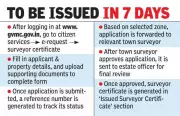
GVMC introduces an online system for survey certificates for plots & buildings, ending manual visits. Get your certificate within 7 days. Apply now on the official website.

Panjab University will spearhead initiatives on air quality monitoring, tourism, anaemia screening, entrepreneurship & skills after NITI Aayog's approval. All projects must finish by March 2026.

India is set to overhaul its property registration by linking every transaction to precise GIS maps, phasing out vague boundary descriptions. This nationwide digital shift aims to bring clarity and reduce disputes.

Gen Z and millennials joined a heritage tree-mapping event at Pune's Ganeshkhind Garden, highlighting rising interest in conservation. The activity comes as the PMC plans an STP in the area.

Lucknow Municipal Corporation introduces a new Property Tax Management System (PTMS) with unique 16-digit IDs for all properties. Aimed at boosting transparency and compliance, it links to the Smart City Command Centre. Read more.

India launches NMHS-2, its first national mental health survey since 2015, covering all states & UTs. It aims to assess post-pandemic mental illness burden and guide policy. Read the key details.

Participate in India's Biggest Habit Index survey for a chance to win a ₹5000 Amazon voucher. Discover key trends shaping daily routines across the nation.
A detailed satellite study exposes the destruction of 160 acres of mangroves in Raigad, Thane & Palghar. Environmentalists warn of ecological disaster and demand government action. Read more.

Over 1.3 lakh voters in Bengal's Matua heartland may get hearing notices due to missing ancestry links in draft rolls. Many lack CAA documents, sparking fear in the community. Read the full report.

Ace your UPSC 2026 Prelims prep with this essential Polity & Governance quiz. Test yourself on NALSA, Election Commission mapping, constitutional features, and key Supreme Court rulings.

Ahmedabad's SatLeo Labs uses satellite thermal data to map urban heat, aiding city planning and worker safety. Pilot in Tumakuru shows promise for emissions tracking and heat management.

Varanasi (Kashi) bags the Smart City Innovation Award-2025 for its pioneering 3D Urban Spatial Digital Twin project, a first in India for comprehensive city planning and disaster management.
Rajasthan becomes India's first state with 100% digitised voter lists. CEO Naveen Mahajan announces success of SIR-2026 programme, reducing document verification needs. Voters urged to check draft list on Dec 16.

Madhya Pradesh nears completion of digital voter mapping, with 99.66% forms digitised. Draft rolls to be published on December 16. Read the full update.

Gurgaon's MCG initiates a comprehensive baseline survey of sectors 1-57 to create a geo-referenced database for roads, sewage, water supply & more. Aim: plug service gaps.

ASI introduces a free QR-based virtual tour at Pune's ancient Pataleshwar Caves, featuring 360-degree visuals and multilingual narration to enhance heritage accessibility. Explore now!

India witnessed 1.77 lakh road crash deaths in 2024, averaging 485 daily. National Highways see 31% of fatalities. Govt plans AI mapping, stricter licenses to curb crisis.

Trichy district's flood-vulnerability mapping identifies 373 sq km as high-risk, affecting 2 lakh people. Officials plan mock drills and annual updates for monsoon preparedness.

Panchkula police have identified 150 crime hotspots. DCP Anshu Jain details the strategy involving beat officers and tech to enhance safety. Read the full plan.

Bokaro DC Ajay Nath Jha orders schools to complete Aadhaar seeding and bank mapping within 72 hours. Principals' salaries may be withheld for non-compliance. Scholarship applications are also under review.

The Centre's NAKSHA programme uses drone surveys to create digital urban land records, aiming to curb illegal construction and simplify property deals for 600 million future city dwellers. Read how it works.

India's digital economy is expanding at 2.6 times its GDP, driving Asia-Pacific's transformation. Discover the key drivers and future projections shaping this rapid growth.

Patna workshop led by CGWB and state officials stresses judicious use of field data in national groundwater mapping. Experts call for a common platform and training for effective resource management.
A Patna workshop organized by CGWB and state officials emphasized creating a common data platform for groundwater mapping. Experts called for judicious data use and specialized training for effective resource management.
Kanyakumari police arrest 458 people, seize 150kg ganja in 11-month special drive. Financial networks targeted as investigation intensifies. #DrugBust #Kanyakumari

Delhi government is developing DAMIS software to map all government land, track encroachments, and enable better urban planning. Complete details about the new land management initiative.