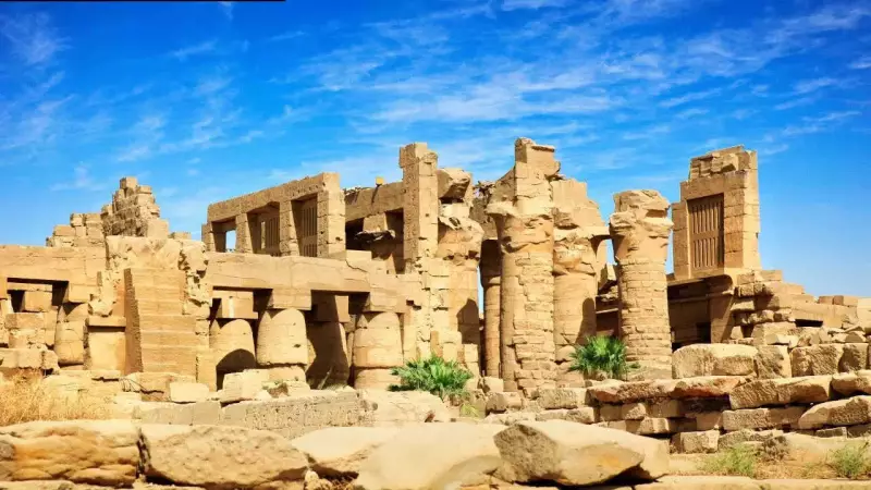
Ancient Karnak Emerged from a Landscape Sculpted by Water and Stone
For more than a century, archaeological excavations at Karnak have primarily concentrated on temples, walls, and inscriptions, while the ground beneath these monumental structures received comparatively less attention. A revolutionary new geoarchaeological study has now dramatically shifted this focus, revealing fascinating insights about how the River Nile shaped this iconic site.
Drilling Reveals Karnak's Hidden Riverine Past
By drilling dozens of sediment cores across Karnak and its surrounding areas, researchers have meticulously traced how the River Nile once flowed through this region. Their findings indicate that the vast temple complex was constructed on a natural river terrace that was once encircled by multiple channels. This geographical setting may have resonated with ancient Egyptian cosmological concepts of a sacred mound rising from primordial waters.
The Island Temple: Karnak's Geological Foundation
The study, titled "Conceptual origins and geomorphic evolution of the temple of Amun-Ra at Karnak (Luxor, Egypt)," demonstrates that Karnak was not randomly positioned on the floodplain. Beneath the magnificent temples lies substantial sandy deposits left by fast-flowing water thousands of years ago. These sands form an elevated terrace that stands higher than the surrounding land.

During its initial formation, this area would have been unsuitable for permanent settlement due to seasonal flooding. Only later, when the Nile carved channels on both sides, did it create a stable platform that humans could occupy. The research helps narrow down when permanent construction at Karnak became feasible, offering a more nuanced understanding of how landscape and religious belief developed in tandem.
Timing of Settlement and River Transformation
Sediment dating suggests this terrace became dry and stable around 2520 BC, with a margin of several centuries. This timing corresponds with the oldest pottery discovered at the site, indicating early occupation during the late Old Kingdom or First Intermediate Period. The evidence strongly supports the theory that Karnak only became viable for settlement once the river landscape underwent significant transformation.
Karnak as a River Island
Cores extracted across the site reveal traces of former river channels both east and west of Karnak. These channels appear to have enclosed the terrace, effectively transforming it into an island of higher ground. Smaller channels even traversed parts of the site itself. Over centuries, some channels naturally filled with silt, while others remained active for extended periods. The emerging picture is not of a static environment but rather a dynamic mosaic of land and water that gradually evolved.
Human Adaptation to Shifting Waters
As Egyptian dynasties rose and fell, the Nile continued its natural movement. During the Middle Kingdom, some channels began silting up, connecting previously separate land areas. By the New Kingdom, parts of the river system were intentionally filled with sand, likely to support ambitious construction projects. These actions indicate that ancient Egyptians were not merely reacting to natural changes but actively shaping their environment to meet religious and political objectives.
Major Nile Branch East of Karnak
One of the study's most significant findings is evidence of a substantial Nile channel flowing east of the temple complex. Pottery and sediment analysis confirm this channel was active from at least the First Intermediate Period through the New Kingdom. At its maximum extent, it may have spanned several hundred meters in width. This channel eventually shifted eastward and silted up, transforming into a floodplain by the late classical period.

Landscape Mirroring Ancient Belief Systems
The concept of Karnak rising from surrounding waters has long been documented in ancient texts and temple symbolism. Egyptian creation myths frequently describe a primordial mound emerging from chaotic waters. While researchers cautiously avoid making definitive claims, the physical reality of an island terrace surrounded by channels aligns remarkably well with this mythological imagery. This suggests that natural features may have reinforced religious significance, even if they weren't the original reason for selecting the site.
A Deeper Understanding of a Familiar Monument
This study doesn't dramatically rewrite Karnak's history but rather adds substantial depth to our understanding. By integrating sediment core analysis, pottery examination, and advanced dating techniques, it fills crucial gaps left by previous archaeological work. The result is a more comprehensive picture of a landscape in constant motion, where temples evolved alongside changing river systems. Karnak emerges not as a static monument but as an integral part of a living floodplain, continuously shaped by time, water, and deliberate human decisions.