Hyderabad's NH-65: A 12-Lane Highway Transforms into a Deadly Urban Corridor
Originally envisioned as a transformative 12-lane high-speed corridor to boost Hyderabad's eastern growth belt, National Highway-65 has instead become a symbol of profound urban planning failure. The stretch between Chintalkunta and Pedda Amberpet, engineered for uninterrupted vehicular flow, is embedded within dense urban life where thousands of residents cross daily to access homes, schools, workplaces, and markets.
Alarming Accident Data Reveals Systemic Disconnect
Accident data for 2025 exposes the severe scale of this infrastructure mismatch. Along the 12-kilometer NH-65 corridor passing through Abdullapurmet, Hayathnagar, LB Nagar, and Vanastalipuram, authorities recorded a staggering 961 accidents. These incidents resulted in 816 people injured and 134 fatalities. Despite its expressway-like design, the highway functions as a routine pedestrian crossing for communities living on either side, creating a dangerous environment where high-speed traffic meets daily urban mobility needs.
Hayathnagar: Highest Accident Zone with Pedestrian Focus
Hayathnagar stands out as the most hazardous segment, reporting the highest number of accidents (304) and injuries (260). The victim profile here challenges common perceptions about road safety. Seventy-two pedestrians were injured or killed in Hayathnagar—the highest pedestrian casualty count across the entire corridor—while only two drunk driving cases were registered during the year. This significant disparity suggests that reckless driving alone cannot explain the tragedy, pointing instead to the critical absence of safe crossing infrastructure.

Widespread Impact Across Multiple Neighborhoods
The danger extends throughout the corridor. Vanastalipuram recorded 251 accidents with 207 injuries and 65 pedestrian victims. Abdullapurmet, though reporting fewer pedestrian cases, witnessed the highest death toll with 49 fatalities. LB Nagar registered 37 pedestrian casualties. Across all four police jurisdictions, drunk-driving cases remained in single digits, indicating that enforcement measures cannot compensate for fundamental structural shortcomings in road design.
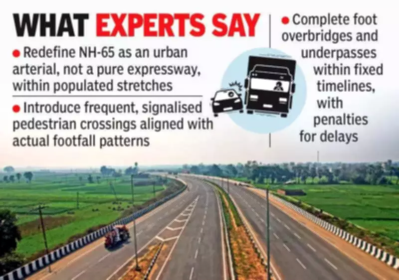
Urban Planners Identify Critical Design Flaws
Urban planning experts emphasize that NH-65 exemplifies a highway designed for speed but cutting through populated zones where essential services sit directly opposite one another. Safe crossing points are sparse, distant, or incomplete, forcing residents to rely on risky informal crossing locations that have become routine despite their danger. The highway has effectively divided neighborhoods, transforming what were once short walks into long detours or hazardous dashes across multiple fast-moving lanes.
Residents Face Daily Life-Threatening Challenges
Local residents describe how the highway has created dangerous divisions within their communities. With vehicles traveling at near-expressway speeds, even minor errors in judgment can prove fatal. The absence of adequate pedestrian infrastructure means that accessing basic services requires navigating a lethal obstacle course where survival depends on timing and luck rather than safe urban design.
Broader Implications for Hyderabad's Development
As Hyderabad continues its eastward expansion, NH-65 has become more than just a transportation corridor—it serves as a critical measure of whether infrastructure growth can coexist with basic safety requirements. Current trends suggest that without urgent design corrections and pedestrian-focused interventions, the pursuit of vehicular speed will continue to exact a heavy human cost. The highway stands as a stark reminder that urban development must prioritize human safety alongside mobility ambitions.
The situation on NH-65 highlights a fundamental tension in modern urban planning: how to balance the need for efficient transportation corridors with the safety requirements of communities living alongside them. With hundreds of accidents and casualties already recorded, the corridor demands immediate attention from urban planners, transportation authorities, and policymakers to implement safety measures that protect vulnerable road users while maintaining traffic flow.