Drones Replace Combat Missions in Gadchiroli for Land Mapping Initiative
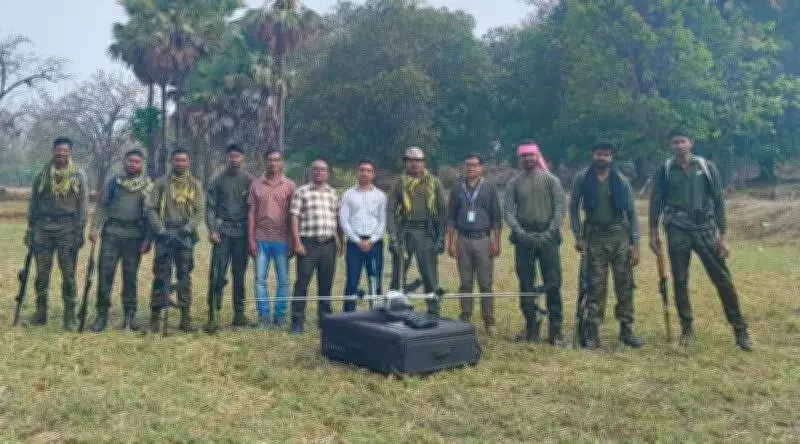
In the remote villages of Gadchiroli district, the familiar whizzing sound of drones overhead and the presence of armed C-60 commandos on the ground once signaled intense anti-Naxal operations during the peak of Left Wing Extremism (LWE). However, in a remarkable transformation, these tools are now being repurposed for a peaceful and developmental mission.
From Conflict to Development: A New Era for Gadchiroli
Last Sunday, the drones' cameras were not scanning for armed rebels but were instead digitally mapping land parcels in Bhamragadh taluka, a remote area in Gadchiroli. Although Maoist activity has significantly declined, making them largely a historical footnote in the district, armed commandos accompanied the land surveyors as a precautionary measure, highlighting the region's sensitive past.
This survey is part of the Maharashtra government's ambitious Swamitva scheme, which aims to grant land ownership to local residents. Bhamragadh, bordering Chhattisgarh and once a gateway to the fallen LWE bastion of Abujmarh, is now at the forefront of this initiative.

Phase One: Digital Mapping for Ownership Clarity
In the first phase of the Swamitva scheme, the state government is digitally mapping all land parcels in and around villages before proceeding with the handover of ownership documents. So far, 10 villages in Bhamragadh taluka have been covered under the drone survey, with revenue authorities awaiting security clearance to expand to other areas.
Collector Avishyant Panda emphasized that the survey work is being expedited, leveraging the improved security scenario following a decline in Naxal activity in Bhamragadh taluka. Since this is the first-of-its-kind exercise for the district, Collector Panda and District Superintendent of Land Records Vijay Bhalerao are personally supervising every development to ensure accuracy and efficiency.
Expanding the Survey: Next Steps and Challenges
The next step involves venturing deeper into the taluka, closer to the Chhattisgarh border. Deputy Superintendent of Land Records Vitthal Jadhav stated, "Drone surveys for Binagunda, Damanmarka, and Kuwwakodi villages would be carried out once police clearance is obtained." This cautious approach reflects the ongoing need for security in these historically volatile regions.
Jadhav also informed that drone mapping has been completed for several villages, including Kathlasur, Bhatpar, Hitlawara, Juwwi, Darbha, Malenga, Mardahur, Visamundi, Tekla, and Gundurwahi. This progress marks a significant milestone in the district's development journey.
Benefits of the Swamitva Scheme
The Swamitva scheme provides rural residents with officially demarcated property boundaries and legal ownership certificates, which are expected to simplify access to institutional credit and foster economic growth. An official explained, "Several villages in Bhamragadh will now be covered. Drone technology is being used to prepare accurate measurements, maps, and property records of inhabited village land, which is expected to help resolve property disputes and simplify the division of assets."
This initiative not only addresses long-standing issues of land ownership but also leverages technology to bring transparency and efficiency to rural governance, setting a precedent for other conflict-affected regions in India.