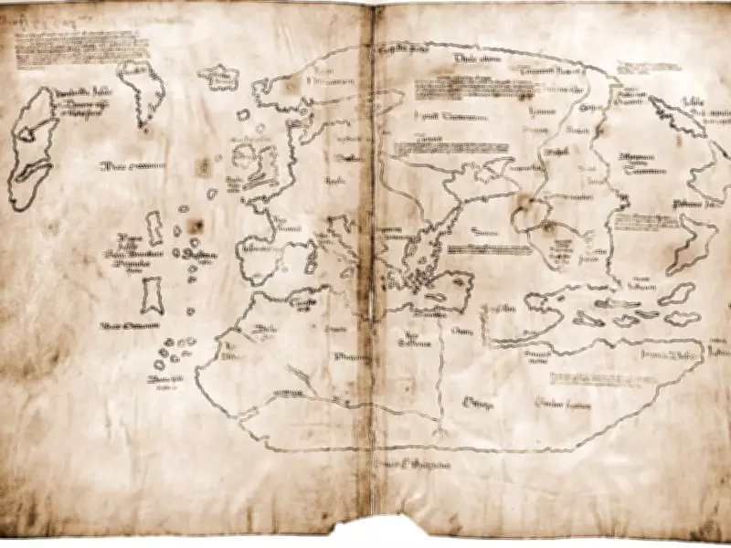
For decades, a mysterious parchment known as the Vinland Map stood at the center of one of the biggest controversies in historical archaeology. If genuine, the map would have offered strong visual evidence, providing dramatic proof that Norse explorers had mapped the North American coast well before Christopher Columbus sailed. However, the controversy surrounding the map was largely resolved by modern scientific analysis. The entire document was subjected to a battery of high-tech tests by conservation experts at Yale University, which revealed that the map was not a medieval treasure but a clever forgery from the 20th century.
A Map That Would Rewrite History
The Vinland Map first attracted worldwide attention because it seemed to solve a difficult historical riddle with a single stroke of the pen. It depicted a large island in the Atlantic Ocean called “Vinlanda,” suggesting that medieval Europeans had extensive geographic knowledge of the New World. The map was steeped in so much history that it quickly became the focus of intense fascination and controversy. Scholars debated its authenticity passionately for years. Some noticed oddities in the handwriting and the style of the drawings, while others speculated that the document could be a genuine relic from the Middle Ages. According to an article in the Yale News, this long-standing academic controversy stemmed from the fact that early scientific examinations were limited to small, isolated areas of the parchment. Forensic sampling from a small, isolated spot can be misleading in cases of deliberate forgery. With improved conservation standards, researchers adopted a different approach. Instead of viewing the map as a fragile historical symbol, they began to treat it as a physical specimen, examining the entire surface line by line and pigment by pigment to determine if it could withstand modern scrutiny.
What High-Tech Tests Revealed About the Ink
The controversy reached a definitive turning point when a scientific and conservation team mapped the chemical composition of the ink across the entire document. The scientists employed a complex technique called X-ray fluorescence spectroscopy to scan the lines and text of the map, identifying the exact elements present in the material. The results undermined claims that the ink was medieval. Yale University’s detailed reanalysis suggested the presence of detectable levels of titanium consistent with modern titanium-white pigments (titanium dioxide) in the ink. This scientific signature did not match the traditional iron-gall ink used by medieval scribes to create documents. Instead, the chemical pattern perfectly matched titanium-white pigments, which were not commercially produced until the early 20th century. The presence of these modern titanium traces throughout the writing on the map led curators to conclude that there was no longer any reasonable doubt that the document was a modern fabrication.

Evidence from the Back of the Parchment
The forensic investigation did not stop with the front of the map. Conservators also turned their attention to the other side of the parchment, where a short Latin note had been written. This inscription on the back side was one of the most damning pieces of evidence against the authenticity of the artifact. A later story from the Yale News reported that the Latin text on the back had also been deliberately overwritten with the same modern, titanium-bearing ink. This important detail changed the way historians viewed the object. It demonstrated that the map was not an authentic medieval artifact that had been accidentally contaminated or handled differently over the years. Rather, it was a conscious, calculated endeavor to manipulate the parchment to make it appear older and more historically significant than it actually was. The matching chemical evidence on both sides provided an unassailable forensic case that exposed the deep deception built into the manuscript from the moment it was created.

Viking Evidence Remains Independent
As the scientific verdict became more certain, institutions came to terms with the reality of the hoax. The Beinecke Rare Book and Manuscript Library at Yale has updated its catalog, reclassifying the map from a celebrated historical breakthrough to a famous teaching tool on the history of cartographic forgery. Today, the map serves as a vital case study in the interplay of trust, skepticism, and science in museum collections. Crucially, the scientific debunking of the Vinland Map does not change the factual reality of Viking exploration. The actual archaeological finds at L’Anse aux Meadows in Newfoundland had already fully confirmed the physical presence of Norse explorers in North America, the Yale researchers stressed. The map is a forgery, but it is not the source of the Viking exploration story, and its exposure does not destroy that narrative. The romantic myth of the map may have lost its magic in the laboratory, but the real history is safely buried in the ground, validated by real archaeology, not fraudulent ink.