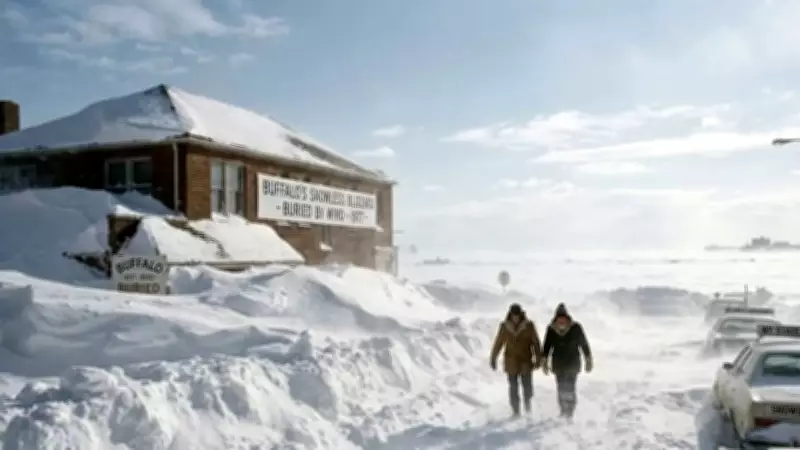
The 1977 Buffalo Ground Blizzard: A Meteorological Anomaly
In late January 1977, the state of New York witnessed a remarkable challenge to conventional neurobiological science through an extraordinary meteorological event. An anomalous blizzard, specifically classified as a ground blizzard, swept across the region with sustained winds reaching near-hurricane speeds of 69 miles per hour. This powerful weather system did not follow the typical pattern where clouds supply snowfall from the sky. Instead, it demonstrated a fascinating phenomenon where wind alone could create catastrophic winter conditions.
How Snow Accumulated Without Falling From Clouds
The winter storm that struck Buffalo, New York in 1977 resulted from an unusual weather event known as a ground blizzard. This specific type of blizzard occurs when powerful winds transport snow that is already present on the ground rather than relying on atmospheric precipitation. Before January 28, Buffalo had already received record-breaking amounts of snow from previous storms. When an arctic cold front moved through the area, it generated high-speed winds with gusts exceeding 75 miles per hour.
These intense winds blew across frozen Lake Erie, which was covered with thick, loose powder snow from earlier accumulations. The result was massive quantities of snow being lifted and transported directly into the city of Buffalo, creating the illusion of falling snow despite clear skies with no actual precipitation occurring. This event proved that blizzards could happen without adding new snowflakes to existing accumulations, relying solely on the movement of pre-existing environmental materials.

The Science Behind the Frozen Lake Phenomenon
What made this event particularly unusual was that most lake-effect snowstorms require open water to provide moisture for cloud formation and precipitation. In this case, the entire surface of Lake Erie was completely ice-covered. According to the National Oceanic and Atmospheric Administration (NOAA), the legacy snowpack from a month-long cold spell had left the remaining snow on the lake extremely light and dry.
The combination of atypical wind patterns and extremely low temperatures created perfect conditions for what meteorologists call a whiteout or zero visibility situation. This dangerous condition persisted for an extended period, trapping approximately 17,000 people inside their vehicles and workplaces throughout Western New York and Southern Ontario. The storm demonstrated that weather events could occur independently of new material introduction, relying entirely on the transportation of existing environmental elements.
The Unprecedented Cleanup Operation
The powerful winds did more than simply move snow from one location to another. They also compressed and transformed the snow into a hard, concrete-like substance. The extreme wind speeds compacted individual snow crystals so effectively that snow drifts reached heights exceeding 30 feet. These formations were too heavy and dense to be removed with standard snowplowing equipment, presenting unprecedented challenges for cleanup efforts.
In response to this emergency, President Jimmy Carter issued his first federal declaration of emergency resulting from a snowstorm. The operation, dubbed Operation Snow Go, mobilized the United States Army Corps of Engineers and the National Guard. These teams deployed heavy industrial loaders and trenching machines to literally carve out roads through the solidified snow and ice, gradually reopening the paralyzed city.
Meteorological Significance and Legacy
This historic event highlighted several important meteorological principles. First, it demonstrated that significant snowfall could occur through the transportation of previously fallen or formed snow particles by powerful winds. Second, it revealed that weather phenomena are not necessarily dependent on new material but can result solely from moving pre-existing materials within the environment.

The 1977 Buffalo ground blizzard also presented challenges for conventional weather monitoring systems. Since the blowing snow consisted entirely of recycled ice crystals rather than new precipitation, traditional weather satellite precipitation sensors could not detect the event as it was occurring. This limitation highlighted the need for more sophisticated monitoring approaches for similar weather anomalies in the future.
Ultimately, the storm produced total snowfall accumulations reaching or exceeding 45 feet in Buffalo while creating whiteout conditions that brought the region to a standstill. This remarkable meteorological event remains a significant case study in atmospheric science, demonstrating nature's capacity to create winter storms through unconventional mechanisms that defy ordinary expectations about how snow accumulates during blizzard conditions.