Groundbreaking 3D Imaging Exposes Hidden Structure of Turkey's Critical Earthquake Fault
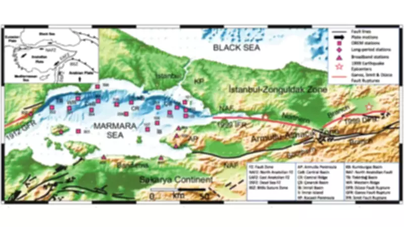
For decades, researchers investigating seismic hazards in northwestern Turkey have understood the general location of the North Anatolian fault but remained uncertain about its precise behavior beneath the Marmara Sea. This knowledge gap has carried significant implications for earthquake preparedness. The offshore segment lies alarmingly close to Istanbul and has not experienced a major rupture in over two centuries, creating mounting concern among scientists and urban planners alike.
New Study Provides Unprecedented Detail on Subsurface Fault System
A landmark study published in GeoScience World titled '3-D electromagnetic imaging of highly deformed fluid-rich weak zones and locked section of the North Anatolian fault beneath the Marmara Sea' has dramatically enhanced our understanding of this critical seismic zone. By analyzing electromagnetic signals recorded both on land and beneath the sea, researchers have constructed the first comprehensive three-dimensional image of the fault zone below the Marmara Sea.
While the findings do not predict the timing of the next major earthquake, they reveal crucial differences in rock strength at depth and provide valuable insights into how stress accumulates along various segments of the fault system. This represents a substantial advancement in seismic research methodology for offshore fault zones.

Turkey's Seismic Reality: A Nation at the Crossroads of Tectonic Plates
Turkey's elevated earthquake risk stems directly from its geological position at the convergence point of several major tectonic plates. The relentless, gradual movement between these plates releases energy through numerous faults that crisscross the country. Among these geological features, the North Anatolian fault commands particular attention due to its extensive reach and destructive history.
This formidable fault stretches approximately 1,500 kilometers and has generated a devastating sequence of earthquakes throughout the past century. Since the catastrophic 1939 Erzincan earthquake, significant ruptures have systematically progressed westward along the fault line. This westward migration pattern has focused scientific attention on the Marmara Sea region, where the fault transitions offshore before extending toward the Aegean area.
Overcoming Research Challenges in Marine Seismic Studies
The Marmara Sea fault segment has remained particularly enigmatic compared to its terrestrial counterparts. Scientific investigation has been hampered by limited permanent instrumentation on the seafloor and the inherent constraints of conventional seismic imaging techniques in offshore environments. Consequently, researchers have maintained only a fragmented understanding of the crustal structure beneath the sea, especially at the greater depths where earthquakes typically initiate.
This incomplete picture has complicated efforts to accurately assess stress distribution along the fault and identify which specific sections might be most vulnerable to future rupture events. The absence of detailed subsurface information has represented a significant obstacle in refining seismic hazard assessments for the densely populated Istanbul metropolitan region.
Electromagnetic Technology Provides Revolutionary Subsurface Vision
To address this critical knowledge gap, the international research team employed magnetotelluric data collected from more than twenty monitoring stations positioned throughout the Marmara Sea and surrounding coastal areas. These sophisticated instruments measure natural fluctuations in Earth's electric and magnetic fields, with signal variations reflecting how easily electricity conducts through underlying rock formations.
By integrating these measurements into an advanced three-dimensional inversion model, scientists generated unprecedented images of electrical resistivity extending tens of kilometers beneath the seafloor. The resulting model reveals a complex mosaic of zones with distinctly different physical properties.

Areas exhibiting low electrical resistivity are interpreted as fluid-rich zones with reduced mechanical strength. These regions typically correlate with clusters of minor seismic activity, suggesting that accumulated stress might release more gradually through frequent small earthquakes.
Conversely, zones displaying high electrical resistivity appear to be mechanically stronger and more rigid. These sections are likely locked, meaning they resist gradual movement and instead accumulate tectonic stress over extended periods, potentially leading to more substantial rupture events when they finally release.
Boundary Zones Emerge as Critical Seismic Factors
One of the study's most significant discoveries involves the crucial role played by boundaries between these different geological zones. Similar patterns have been observed along other major fault systems worldwide, suggesting a fundamental principle in earthquake mechanics. In the Marmara Sea context, these transitional boundaries may serve as initiation points for larger rupture events.
Rather than identifying a single hazardous location, the research points toward a segmented fault system exhibiting varied behaviors along its entire length. This nuanced understanding represents a paradigm shift from previous, more simplified models of fault behavior.
Enhancing Seismic Hazard Assessment for Istanbul Region
While the study explicitly avoids providing short-term earthquake forecasts, its scientific value lies in fundamentally improving our comprehension of how fluids, rock strength, and fault structure interact beneath the Marmara Sea. For a metropolitan area facing substantial seismic risk, this clearer geological picture will inform future hazard assessments, building codes, and emergency preparedness strategies.
The research provides civil authorities and urban planners with enhanced data to develop more resilient infrastructure and evacuation protocols. By understanding which fault segments are locked versus those that release stress gradually, scientists can better estimate potential earthquake magnitudes and ground shaking intensities for different scenarios.
This groundbreaking work establishes a new benchmark for offshore fault investigation and demonstrates how innovative geophysical techniques can illuminate previously hidden aspects of our planet's dynamic crust. As monitoring technology continues to advance, similar approaches may be applied to other seismically active regions worldwide, potentially saving countless lives through improved earthquake preparedness.