A recent study conducted by Pandit Deendayal Energy University (PDEU) has revealed that heat exposure in Ahmedabad is heavily dependent on location. Eastern wards, characterized by high population density, sparse tree cover, and temperatures up to 8 degrees Celsius higher than surrounding rural areas, are particularly vulnerable. In contrast, western areas experience relatively cooler conditions due to lower population density and better green cover.
Relative Heat Risk Index
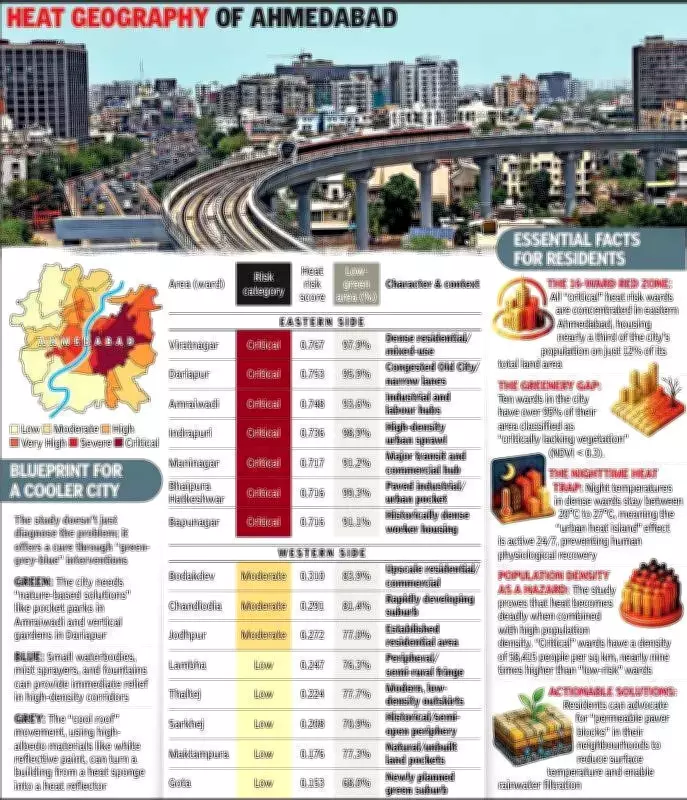
Researchers Shubham Kela, associate professor Anurag Kandya, and Viral Patel developed a Relative Heat Risk (RHR) Index using NASA satellite data. This index combines land surface temperature, green cover, and population density into a single score. The findings are stark: 16 eastern wards fall into the critical heat risk category. With an average density of 58,415 people per square kilometer and minimal tree cover, these wards house 32.4% of the city's population. An additional six wards classified as severe risk push that figure to 44%, meaning nearly half the city lives in thermal danger.
Critical Zones and Rankings
The critical zone itself covers just 53.6 square kilometers, making it one of the most densely populated and heat-stressed urban pockets in the country. Viratnagar tops the danger index with a score of 0.767, followed by Dariapur (0.753), Amraiwadi (0.748), Indrapuri (0.736), and Maninagar (0.717), all located in the east. Conversely, lower-risk wards include Gota (0.153), Maktampura (0.176), and Sarkhej (0.208), mostly in the west.

Even the greener areas face challenges. Gota, the greenest ward, still has 68% of its land below the minimum vegetation threshold for urban areas, defined in the study as a Normalized Difference Vegetation Index (NDVI) of 0.3. In 10 wards, over 95% of land falls below this baseline.
Implications for Policy
Professor Kandya emphasized that heat is a city-wide issue requiring targeted action. The study prioritizes land surface temperature over ambient temperature because it is easier and cheaper to measure across large areas, making it a practical tool for resource-limited administrations. By identifying the most vulnerable pockets, the index offers a clear starting point for municipal interventions. As Kandya noted, the data allows officials to identify vulnerable pockets and provides a clear starting point for municipal interventions.