Satellite Data Reveals Himalayan Vegetation Decline Due to Climate Stress
Satellites orbiting the Himalayas are now reading the mountains like a detailed, slow-moving diary, capturing the subtle shifts in grasslands, forests, and valley flora that signal both natural rhythms and growing environmental strain. An extensive analysis of two decades of data from Uttarakhand demonstrates how closely this region responds to climatic changes and how those vital rhythms are beginning to falter under increasing pressure.
Mountain Ecosystems as Climate Indicators
Mountain ecosystems are known to react more swiftly than most landscapes to fluctuations in temperature and rainfall patterns. With global surface temperatures on the rise and precipitation becoming increasingly erratic, these changes are already exerting a profound influence on plant growth, soil moisture levels, and snow cover dynamics. Scientists emphasize that continuous, long-term monitoring is absolutely essential for governments to effectively prepare for and mitigate the impacts of floods, droughts, and biodiversity loss in these sensitive areas.
Advanced Monitoring Techniques
To meticulously track these environmental shifts, researchers from the Aryabhatta Research Institute of Observational Sciences (ARIES) in Nainital, an autonomous institute under the Department of Science and Technology (DST), collaborated with both Indian and international partners. They utilized the powerful Google Earth Engine (GEE) platform, which processes vast volumes of satellite data efficiently, enabling the study of land degradation, urban expansion, dust movement, and temperature trends without the logistical burden of storing raw imagery.

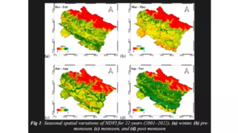
The team examined comprehensive satellite records spanning from 2001 to 2022, relying on the widely recognized Normalised Difference Vegetation Index (NDVI). This index measures how plants reflect light, providing a straightforward indicator of their health and vitality. Lower NDVI values typically correspond to barren surfaces like rock, sand, water, or snow, while higher values indicate lush, dense forests, productive croplands, or thriving wetlands. Additionally, the researchers incorporated the Enhanced Vegetation Index (EVI), which offers improved accuracy in areas with thick biomass and dense vegetation cover.
Key Findings and Environmental Impacts
The findings of the study, led by Umesh Dumka from ARIES and published in the journal Environmental Monitoring and Assessment, reveal clear and predictable seasonal cycles. Both NDVI and EVI values peak following the monsoon season when the hills become lush and green, then decline to their lowest levels just before the rains arrive. While monthly and yearly variations generally follow this familiar pattern, the long-term data graphs show a gradual but unmistakable decline in overall vegetation health.
This decline is strongly linked to a combination of human-induced factors, including deforestation, expanding agricultural activities, illegal logging operations, and rising pollution from nearby towns and industrial zones. The researchers note that pollution does not affect all areas uniformly; some pockets experience significantly heavier damage, compounding the stress already imposed by warming temperatures and unpredictable rainfall. These mounting pressures pose a serious threat to wildlife habitats, river systems, and the livelihoods of millions of people who depend on the mountains and their downstream resources.
Correlation Analysis and Future Implications
Using time-series maps generated through GEE, the scientists compared vegetation trends with detailed climate data and applied Pearson’s correlation analysis to better understand the relationships between these variables. This methodological approach allowed them to pinpoint specific districts where greenery has weakened most sharply, highlighting areas of particular vulnerability.

The authors argue that satellite science can serve as a crucial early-warning system for environmental management. By identifying these vulnerable zones accurately, authorities can proactively plan afforestation initiatives, regulate construction activities, and implement stricter emissions controls before ecological losses become irreversible. The Himalayas, they assert, are now signalling distress through a language of pixels and numerical data. Listening attentively to this message may very well determine how resilient the region remains in the challenging decades ahead.