Indore Records Notable Temperature Increase Amid Changing Weather Patterns
The city of Indore witnessed a substantial rise in both daytime and nighttime temperatures on Sunday, marking a distinct shift from the recent colder conditions. The warmer trend provided noticeable relief from the preceding chill, while partly cloudy skies contributed to maintaining relatively steady atmospheric conditions throughout the day.
Temperature Measurements and Atmospheric Conditions
The maximum temperature climbed to 29.3 degrees Celsius, which represents approximately two degrees above the normal expected range for this period. This reading also showed a significant increase of nearly three degrees compared to Saturday's maximum of 26.4 degrees Celsius. The minimum temperature followed this upward trend, settling at around 15.2 degrees Celsius, about four degrees higher than the typical minimum for this time of year.
Early morning observations at 8:30 am recorded a temperature of 18.8 degrees Celsius with relative humidity measured at 61 percent. Visibility conditions stood at 5000 meters under hazy atmospheric conditions, while winds blew consistently from the east-southeast direction at speeds ranging between 11 to 12 kilometers per hour.

Sky Conditions and Solar Influence
Partly cloudy weather prevailed throughout Sunday, with patches of cloud cover drifting across the sky at regular intervals. The cloud presence served to reduce direct solar glare during certain periods, though it did not completely block sunlight, allowing temperatures to rise steadily throughout the daylight hours. This atmospheric configuration created a balanced environment where warmth accumulated without excessive solar intensity.
Meteorological Systems Influencing Regional Weather
Meteorological officials have identified several weather systems currently influencing the regional pattern. A western disturbance in the form of cyclonic circulation is present over north Pakistan at heights of 3.1 and 5.8 kilometers, with an associated trough extending at higher atmospheric levels. Another induced cyclonic circulation lies over north Rajasthan and south Haryana, while a trough runs from central Maharashtra through Gujarat toward this system.
Additionally, strong upper-level westerlies continue to persist over various parts of the country, contributing to the overall weather dynamics affecting central India.
Forecast and Regional Weather Outlook
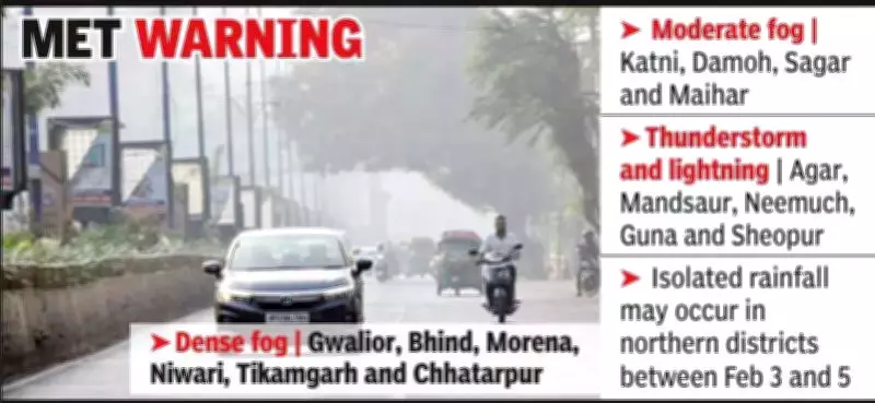
Arun Sharma from the Bhopal Meteorological Office confirmed that no cold day conditions were recorded in central western Madhya Pradesh during the last 24-hour period. Looking ahead, meteorological predictions indicate that dense fog is likely in extreme northern districts including Gwalior, Bhind, Morena, Niwari, Tikamgarh, and Chhatarpur on Monday morning.
Furthermore, isolated rainfall may occur in northern districts between February 3 and 5 as a new western disturbance approaches northwest India. No specific weather warnings have been issued so far for the immediate region surrounding Indore, though residents are advised to monitor updates as these weather systems develop and move across the subcontinent.