Residents of Indore can finally expect some respite from the recent biting cold as weather officials predict a steady warming trend over the coming days. After a spell of significantly low temperatures and sharp contrasts between day and night, the city is poised for a gradual climb in the mercury.
Met Department Forecasts Warming Trend
According to the meteorological department, both maximum and minimum temperatures are set to increase over the next four days. This shift is attributed to the weakening influence of recent western disturbances, which is leading to clearer skies and more intense sunshine during daylight hours.
Arun Sharma, a Met scientist based in Bhopal, confirmed the trend. "There will be a gradual increase of around 2 degrees Celsius over the next 4 days. Night temperature will also rise slowly, reducing the intensity of cold," he stated. This forecast indicates a welcome change from the pronounced chill that has gripped the city in the late evenings and early mornings.

Recent Temperature Swings in Indore
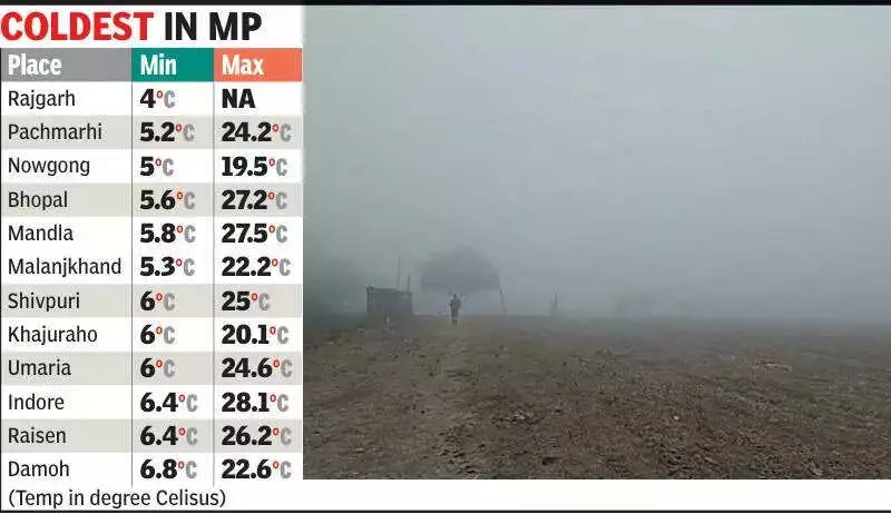
The warming pattern has already begun to manifest. On Monday, Indore recorded a maximum temperature of 28.1 degrees Celsius, which is approximately 2 degrees above the normal average for this season. This reading followed Sunday's maximum of 27 degrees Celsius, showing a consistent upward trajectory in daytime heat.
However, the nights have continued to be cold. The minimum temperature recorded on the intervening night of Sunday and Monday was a chilly 6.4 degrees Celsius, marking a significant 5 degrees below the normal level. This contrast kept the cold feeling largely confined to the late evening and early morning periods.
Synoptic Systems Behind the Weather Change
Meteorological officials explain that the recent fluctuations are directly linked to evolving synoptic weather systems over north and northwest India. The primary factor is the diminishing impact of western disturbances over central India.
Key systems currently influencing the region include:
- A fresh western disturbance, observed as a trough about 5.8 kilometres above sea level, is currently positioned along longitude 52°E, north of latitude 30°N.
- A powerful subtropical westerly jet stream with core wind speeds nearing 287 kilometres per hour is prevailing at an altitude of roughly 12.6 kilometres above south Rajasthan.
- Another western disturbance trough, previously aligned along longitude 60°E, has already moved east-northeastwards.
As the effect of these systems wanes over central India, weather conditions are stabilising. This stability is the primary driver behind the anticipated gradual rise in temperatures, offering a break from the recent cold spell for the people of Indore.