Indore Experiences Unusual February Weather Phenomenon After Ten-Year Dry Spell
The city of Indore witnessed a remarkable meteorological event as unexpected late-night showers and powerful gusty winds dramatically transformed the typical February climate. Thunderstorms developed suddenly after midnight, delivering brief but intense precipitation accompanied by strong winds that caught numerous residents completely unprepared.
Record-Breaking Rainfall and Temperature Changes
Indore recorded precisely 7.3 millimeters of rainfall between midnight and early morning hours, beginning with moderate late-night showers that transitioned into light drizzle by dawn. This weather event represents the city's first measurable February rainfall in an entire decade, bringing refreshing cooler winds reaching speeds up to 33 kilometers per hour and causing a noticeable sudden temperature decline.
By Thursday morning, the atmosphere felt distinctly cooler and fresher throughout the city. With persistent cloudy skies and residual rainfall effects, the daytime maximum temperature dropped significantly to 28.6 degrees Celsius, representing nearly three degrees lower than Wednesday's reading of 31.2 degrees. The minimum temperature registered at 15.2 degrees, slightly above normal levels, yet the combined influence of extensive cloud cover and overnight precipitation created an overall cooler atmospheric tone throughout the day.

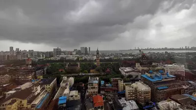
Visible Impact and Meteorological Explanation
Around 4 PM on Thursday, dark clouds once again gathered over the city's skyline, raising expectations among residents for another potential rainfall episode. In multiple residential neighborhoods, fallen leaves and scattered small branches along roadways provided clear evidence of the powerful midnight winds that had swept through the area.
According to authoritative sources at the Weather Centre in Bhopal, this unusual weather pattern connects directly to an active western disturbance currently affecting the region. Dr. Divya Surendran, a prominent meteorologist, explained that a persistent cyclonic circulation continues over north Rajasthan and adjoining Punjab areas, with a trough extending toward Gujarat. The sub-tropical westerly stream remains particularly active over northwest India currently, with another western disturbance likely to influence the broader region beginning February 22.
Broader Regional Weather Patterns
Across Madhya Pradesh state, scattered rainfall reports emerged from multiple districts including Dhar, Ujjain, Bhopal, and Neemuch. Dhar district recorded the highest rainfall measurement in the entire state at 26.2 millimeters. Strong winds were observed in several western districts, while hailstorms were specifically reported in both Neemuch and Mandsaur regions, indicating widespread atmospheric instability throughout central India.
The unexpected February weather event in Indore serves as a significant meteorological occurrence, breaking a ten-year dry pattern during what is typically one of the driest months in the region's annual climate cycle. Residents continue monitoring weather developments as additional western disturbances approach northwest India in coming days.