
ESA Unveils New Mars Flyover Video Created From Real Spacecraft Data
The European Space Agency has released a remarkable new flyover video that traces a portion of Mars's southern highlands, providing a slow, close examination of one of the planet's most extensively cratered regions. This visual journey focuses specifically on Flaugergues Crater and its surrounding terrain, constructed entirely from authentic spacecraft data rather than artistic interpretation or simulation.
From Orbital Data to Three-Dimensional Landscape
Created using images and elevation measurements collected by the Mars Express mission, the video reveals how profoundly scarred and uneven this Martian region remains. The European Space Agency has transformed high-resolution orbital data into a detailed three-dimensional landscape through careful processing techniques. The source material originates from the Mars Chart image mosaic, compiled from numerous individual orbital passes centered near 20 degrees south and 17 degrees east.
To convert flat images into depth-perceptive visuals, camera data was integrated with a digital terrain model. The resulting three-dimensional surface accurately reflects genuine height variations across hundreds of kilometers of Martian terrain. Every second of the video consists of 50 individually rendered frames, with camera movement following a predetermined, exceptionally smooth path across the landscape.

Scientific Accuracy in Visual Presentation
Subtle lighting effects, carefully added haze, and controlled camera motion provide a genuine sense of scale without artificially dramatizing the landscape. The vertical relief has been intentionally exaggerated by a factor of three to make landforms more comprehensible to viewers. Without this modification, many slopes and hollows would appear significantly flatter than their actual dimensions when viewed from orbital perspective.
The atmospheric haze incorporated into the video serves dual scientific purposes. It realistically represents how dust and light scatter within Mars's thin atmosphere, while simultaneously concealing the edges of the terrain model to create a natural transition to the horizon rather than an abrupt, artificial cutoff. This haze becomes gradually noticeable beyond distances of 250 kilometers.
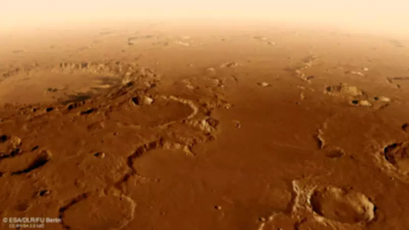
Revealing Ancient Geological Features
The flyover commences along an extensive trench-like formation situated between two steep escarpments known as Scylla Scopulus and Charybdis Scopulus. This geological structure represents a graben, formed when the Martian crust pulled apart through tectonic processes. Stretching approximately 75 kilometers across with a depth drop of about 1 kilometer, the true scale of this feature becomes apparent only as the camera moves steadily along its considerable length.
Large impact craters dominate the surrounding plains throughout the visual presentation. To the left of the initial flight path lies Bakhuysen Crater, measuring approximately 150 kilometers in diameter. As the camera progresses northward, Flaugergues Crater comes into full view. This substantial basin spans roughly 240 kilometers and resides within terrain densely populated by impacts of varying sizes. Sections of its floor exhibit dramatic elevation changes, with rugged areas reaching heights of around 1 kilometer.
What emerges from this European Space Agency production is not merely spectacular visual entertainment but a meticulously crafted scientific record shaped by geology, immense spans of time, and careful data processing rather than imaginative reconstruction. The video draws specifically on data collected by the High Resolution Stereo Camera aboard the Mars Express spacecraft, ensuring authentic representation of Martian topography.

