
Understanding Earth's Grid System: Latitude and Longitude Explained
The Earth's grid system, composed of latitude and longitude lines, is a fundamental framework for mapping and navigating our planet. This intricate network of imaginary lines allows us to pinpoint any location on Earth with remarkable precision, serving as the backbone for global positioning, cartography, and even timekeeping. For students, especially those preparing for competitive exams like the UPSC, grasping this concept is crucial for geography and related subjects.
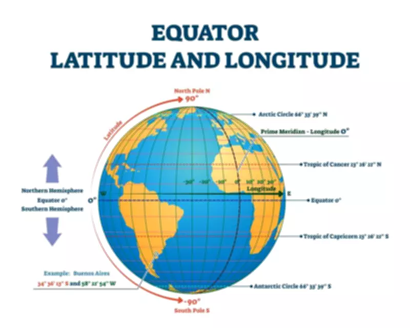
The Basics of Latitude and Longitude
Latitude and longitude are angular measurements that define positions on Earth's surface. Latitude lines, also known as parallels, run east-west and measure distance north or south of the Equator. The Equator itself is at 0° latitude, with the North Pole at 90°N and the South Pole at 90°S. These lines are parallel to each other and are spaced approximately 111 kilometers apart. In contrast, longitude lines, or meridians, run north-south and measure distance east or west of the Prime Meridian, which is set at 0° longitude through Greenwich, England. Longitude lines converge at the poles and are farthest apart at the Equator.
Key Functions and Applications
The primary role of this grid system is to provide a universal method for location identification. By combining latitude and longitude coordinates, we can specify any point on Earth uniquely. For instance, the coordinates of New Delhi are approximately 28.6139° N, 77.2090° E. This system is indispensable for:

- Navigation: Used in GPS technology, aviation, and maritime travel to plot courses and determine positions.
- Cartography: Essential for creating accurate maps and atlases that represent Earth's geography.
- Time Zones: Longitude is the basis for time zones, with each 15° of longitude roughly corresponding to one hour of time difference.
- Climate Studies: Latitude influences climate patterns, helping scientists analyze weather and environmental changes.
Historical Development and Significance
The concept of latitude and longitude dates back to ancient civilizations, but it was refined over centuries. Early astronomers and geographers, such as those in Greece, laid the groundwork by observing celestial bodies. The modern system was standardized in the 19th century with the establishment of the Prime Meridian at Greenwich. Today, it underpins technologies like GPS, which relies on satellites to calculate positions using these coordinates. For UPSC aspirants, understanding this system is vital for topics in physical geography, map reading, and global affairs, as it connects to issues like territorial boundaries and international cooperation.
Challenges and Modern Adaptations
While the grid system is highly effective, it faces challenges such as distortions in map projections and the need for precise measurements. Advances in technology, including digital mapping and satellite imagery, have enhanced its accuracy. Moreover, the integration of latitude and longitude with systems like the Global Positioning System (GPS) has revolutionized how we interact with our world, from everyday navigation to scientific research.
In summary, latitude and longitude form an essential grid system that enables us to navigate, map, and understand Earth. Their applications span from daily life to academic pursuits, making them a cornerstone of geographic literacy. For those studying for exams like the UPSC, mastering this topic is key to excelling in geography and beyond.

