Bengaluru's Urban Evolution: Tracing Five Decades of Growth Through BDA Layouts
The transformation of Bengaluru's urban landscape is not merely visible in its changing skylines but is meticulously documented in the paper trails of layout approvals. Data from the Bangalore Development Authority (BDA) provides a detailed chronicle of how the city's expansion has systematically progressed across different regions over the past fifty years, driven by shifts in land availability, employment opportunities, and infrastructure development.
Southern Foundations: The Early Decades of Planned Growth
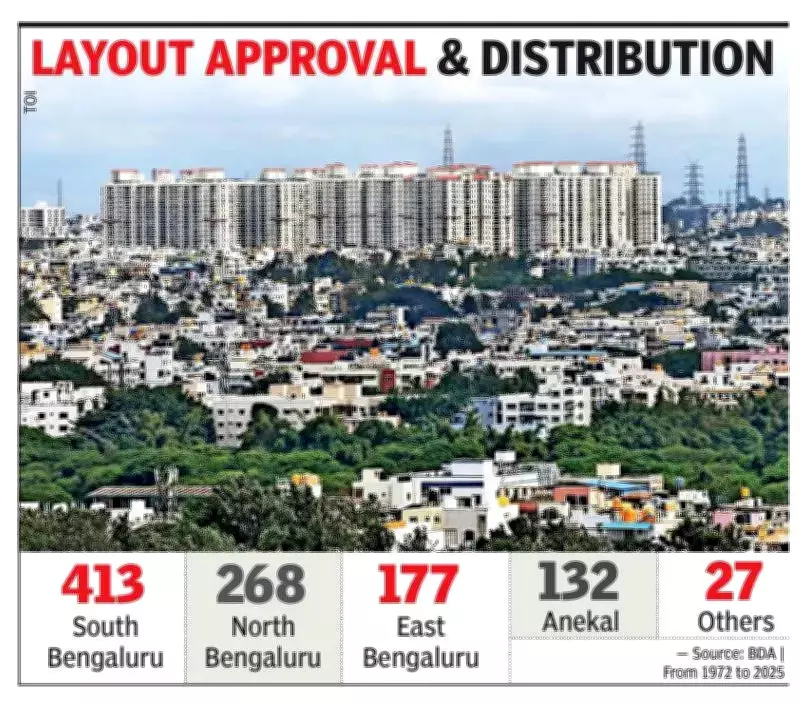
Between 1972 and 2025, the BDA sanctioned an impressive total of 1,017 layouts throughout Bengaluru. In the initial phases, development was predominantly concentrated in south Bengaluru, which continues to represent a substantial 40-43% of all approved layouts to this day. Neighborhoods such as Uttarahalli, Begur, and Kengeri emerged as the primary hubs for planned expansion during this period, collectively accounting for hundreds of layouts.
The southern belt naturally became the starting point for organized urban growth due to the availability of large land parcels and its proximity to the city's older core areas. This strategic advantage facilitated the early establishment of residential and commercial zones, setting the foundation for Bengaluru's subsequent sprawl.

Northward Expansion: The Rise of Cooperative Housing
By the 1980s and 1990s, a significant shift occurred as the city's growth began to move northward. Regions in north Bengaluru, particularly Yeshwantpur and Yelahanka, experienced a notable increase in layout approvals. This phase was largely propelled by the activities of cooperative housing societies, marking a crucial transition where organized residential planning extended beyond its original southern base.
This northward expansion reflected changing demographic patterns and the growing demand for housing in areas that were previously underdeveloped, showcasing Bengaluru's adaptive urban planning strategies.
Eastward Momentum: The IT Corridor's Influence
The most dramatic transformation in Bengaluru's urban growth pattern emerged after the year 2000, with a pronounced eastward tilt. The rise of the Information Technology corridor acted as a powerful catalyst, driving increased layout activity in east Bengaluru and Anekal taluk. Areas that were once peripheral zones with minimal presence in BDA records rapidly evolved into key sites for new development.
This eastward shift directly mirrored the magnetic pull of employment hubs and enhanced connectivity infrastructure, demonstrating how economic forces shape urban geography. A senior BDA official emphasized that approval patterns closely align with market demand and infrastructure readiness, stating, "Applications undergo thorough review by the town planning committee. Following committee approval, plans are issued only after verifying all documents to ensure compliance with regulations." The official added that applications now originate from across the entire city, indicating widespread development interest.
Residential Dominance and Emerging Trends
Despite these geographical transitions, one consistent factor remains: the overwhelming predominance of residential growth. Approximately 90% of all approved layouts—roughly 900—are designated for residential purposes, while industrial and commercial layouts together account for fewer than 20. Officials attribute this disparity to the extensive land requirements of industrial projects, which naturally limit their proliferation within city boundaries.
More recently, increasing land pressure has begun to manifest in vertical expansion trends. In the 2025-26 period alone, the BDA received 179 plan approval requests for both single and multiple plots, signaling a gradual movement toward denser development even as new horizontal layouts continue to emerge.
The data further reveals a dynamic and responsive planning process. At least one in every ten layouts has undergone revisions following initial approval, frequently to accommodate design modifications or infrastructure enhancements as demand escalates.

The Blueprint of Bengaluru's Growth Trajectory
Collectively, these numbers outline a clear evolutionary path: from south-led expansion to northward spread, followed by an eastward push fundamentally shaped by the IT economy. In this manner, BDA's layout approvals serve as an official blueprint documenting how Bengaluru has grown—and continues to actively reshape itself—responding to economic, social, and infrastructural currents over half a century.
The story of Bengaluru's urban development, as told through BDA data, stands as a testament to planned urban evolution, where historical patterns inform future growth while adapting to contemporary demands and opportunities.