
Cyclone Ditwah Intensifies, Threatens Tamil Nadu Coast
The city of Chennai and surrounding regions are preparing for significant rainfall as Cyclone Ditwah, which developed over the Bay of Bengal on Thursday, approaches the north Tamil Nadu coastline. The India Meteorological Department has escalated weather warnings from orange to red alerts, indicating extremely heavy precipitation exceeding 20 centimeters within 24 hours.
IMD Issues Severe Weather Warnings
The meteorological department has placed delta regions and several north coastal districts under red alert status for November 28 and 29. Meanwhile, Chennai and neighboring districts remain under orange alert for heavy to very heavy rainfall between 12cm to 20cm during November 29 and 30.
As of Thursday evening, the powerful cyclonic system was positioned approximately 670 kilometers south-southeast of Chennai. The storm demonstrated rapid intensification, evolving from a depression to a severe cyclonic storm in less than 24 hours, already causing torrential downpours across Sri Lanka.

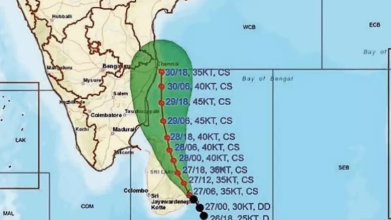
Wind Speeds and Storm Movement Patterns
B Amudha, deputy director general (additional charge) at the regional meteorological centre, IMD, provided detailed forecasts about the storm's impact. "Wind speeds may reach 60-80 kilometers per hour with gusts up to 90kmph in areas along the storm's trajectory," she stated. "For the next two days, strong surface winds of 40-50kmph may prevail over coastal Tamil Nadu, Puducherry and Karaikal."
The cyclone initially moved at approximately 15kmph on Thursday morning before decelerating. The weather system underwent rapid intensification, transforming from a depression into a deep depression overnight.
Regional Impact and Rainfall Distribution
Weather patterns indicate that heavy rainfall activity will initially develop across delta districts before extending to north Tamil Nadu on November 29 and 30. Chengalpet features among six districts under red alert for November 29, with forecasts predicting heavy to very heavy rainfall, including extremely heavy precipitation at one or two locations.
On November 30, Chennai, Chengalpet, Kancheepuram, Tiruvallur and Ranipet districts may experience heavy to very heavy rainfall at multiple locations. For Friday, Chennai and suburban areas might receive one or two periods of light to moderate rainfall accompanied by thunderstorms and lightning. Partly cloudy conditions are expected to maintain maximum temperatures around 30°C and minimum temperatures near 25°C.
While the IMD hadn't confirmed the precise landfall location as of Thursday evening, weather analyst Pradeep John suggested the storm might follow a trajectory similar to Cyclone Ogni from October 2006, potentially bypassing the Chennai coastline. "This track is bound to deliver very heavy rainfall. Cyclone Ogni did exactly that," he noted in his social media update.
In related weather developments, Cyclone Senyar has weakened over the Strait of Malacca after triggering flash floods and landslides in North Sumatra, Indonesia.


