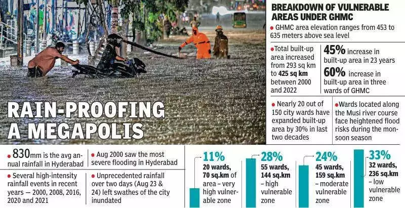
A stark new study has laid bare the escalating flood threat facing India's tech capital. Research conducted by the Tata Institute of Social Sciences (TISS), Hyderabad, concludes that nearly one-third of Greater Hyderabad now resides in zones of high or very high vulnerability to urban flooding.
The Alarming Spread of Concrete and Risk
The primary driver of this growing peril is the city's explosive physical expansion. Since the year 2000, Greater Hyderabad has grown by a massive 45%. This urban sprawl has seen the total built-up area balloon from 293 square kilometres to 425 square kilometres over the past 23 years. This relentless concretisation acts as a seal on the land, preventing rainwater from percolating naturally into the soil. Instead, it creates excessive surface runoff during rains, dramatically increasing the potential for floods.
The TISS analysis quantifies the danger with precision. It finds that 11% of the city's geographical area falls under 'very high' flood vulnerability, with an additional 26% classified as 'highly' vulnerable. This means a combined 37% of Hyderabad's area is at serious risk.

Failing Infrastructure Worsens the Crisis
The study identifies a second, critical failure compounding the problem: the city's stormwater drainage system. Researchers state that the existing network is largely deficient, disconnected, and non-functional due to chronic neglect and poor maintenance.
"In urban areas, natural topography has been significantly altered due to construction activities," the study notes. "Rainfall-induced runoff is expected to be carried by stormwater networks. However, in most parts of GHMC, these networks are nearly non-functional."
A litany of issues has crippled the system's capacity:
- Silting of drains and disconnected stormwater lines.
- Shrinking lake areas that once acted as natural buffers.
- Dumping of solid waste into nalas (drains).
These factors have severely reduced the hydraulic capacity of the network, leaving it utterly incapable of handling the high-intensity rainfall events that are becoming more common.
Geographic Hotspots and Expert Warnings
The flood vulnerability is not evenly distributed. The study maps show that the highly vulnerable wards are heavily concentrated in the southwestern part of Hyderabad. Wards in the western and northwestern regions show moderate vulnerability, while central parts present a mix of moderate and high-risk zones.
Areas along the Musi river course are at heightened risk, especially low-lying locations where rainwater accumulates rapidly and flows downhill during the monsoon.
Urban planners and disaster management experts echo the study's alarm. They warn that without immediate and sustained action to restore stormwater systems, rejuvenate lakes, and enforce strict land-use regulations, the city's flood risk will only worsen amidst increasingly erratic rainfall patterns driven by climate change.
K.M. Lakshmana Rao, a retired civil engineer from JNTUH and a disaster management expert, outlined solutions. "There is a need to have uninterrupted mobility for rainwater flow," he said. He advocated for developing proper slope and gradient systems to facilitate natural drainage, deploying pumps in vulnerable zones, and constructing C-channel drains and reverse drainage systems to efficiently divert excess rainwater and reduce road flooding.
The TISS study serves as a critical wake-up call for Hyderabad, highlighting that its future resilience depends on addressing the twin challenges of unchecked urban expansion and crumbling civic infrastructure.