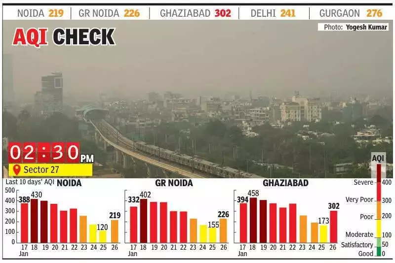
Noida's Air Quality Deteriorates to 'Poor' Category After Brief Respite
As wind speeds decelerated across the region, Noida witnessed a significant decline in its air quality, slipping back into the 'poor' category on Monday. This reversal comes after the city enjoyed two consecutive days of 'moderate' air quality, highlighting the fragile nature of atmospheric conditions in the National Capital Region.
Sharp Decline in Air Quality Index Readings
Noida recorded an Air Quality Index (AQI) of 219 on Monday, a substantial increase from Sunday's reading of 120. The neighboring area of Greater Noida experienced a similar deterioration, with its AQI climbing to 226 from 155 the previous day. Meanwhile, Ghaziabad faced an even more severe situation as its air quality plummeted to the 'very poor' category, registering an AQI of 302 compared to 173 on Sunday.
Visibility Issues and Monitoring Station Data
Visibility across the region remained severely compromised during morning hours, dropping below 500 meters. According to data from the Central Pollution Control Board portal, all four air monitoring stations in Noida recorded 'poor' air quality on Monday. Sector 116 reported the worst conditions with an AQI of 233, followed closely by Sector 1 (AQI 219), Sector 62 (AQI 213), and Sector 125 (AQI 211).

In Greater Noida, Knowledge Park V recorded 'poor' air quality with an AQI of 263, while Knowledge Park III remained in the 'moderate' range at 188. Ghaziabad's monitoring stations revealed particularly concerning readings, with Loni recording the highest pollution levels at 333 AQI in the 'very poor' category. Indirapuram (AQI 292) and Vasundhara (AQI 281) both registered 'poor' air quality, while data from the Sanjay Nagar station was unavailable on Monday.
Meteorological Factors and Weather Forecast
The Indian Institute of Tropical Meteorology (IITM) reported that surface winds on Monday originated from the north, with speeds remaining below 10 kilometers per hour during afternoon hours. These winds further decreased to approximately 8 kilometers per hour during evening and night periods, contributing to the accumulation of pollutants.
Looking ahead to Tuesday, meteorological predictions indicate generally cloudy skies with one or two spells of light rain. These showers are expected to be accompanied by thunderstorms, lightning, and gusty winds reaching speeds of 30-40 kilometers per hour during early morning to forenoon hours. Additional light rain spells may occur in the evening as well.
The predominant surface wind direction is forecast to shift to the southeast, with speeds remaining below 12 kilometers per hour in the morning. Wind speeds are expected to increase to around 15 kilometers per hour in the afternoon before decreasing to approximately 10 kilometers per hour during evening and night hours. These changing weather patterns could potentially influence air quality conditions in the coming days.