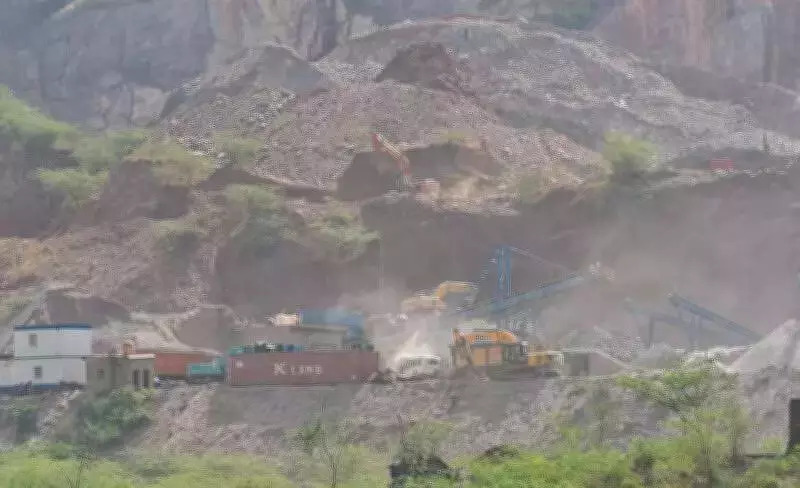
Nuh Administration Deploys Drone Mapping to Combat Illegal Mining in Aravalis
The Nuh district administration in Haryana has launched a comprehensive drone mapping initiative to track fresh violations and monitor ground-level changes across the Aravali region. This strategic move comes as authorities continue their relentless battle against illegal mining activities within the eco-sensitive pockets of the Aravali belt.
Creating a Visual Baseline for Early Detection
Nuh Deputy Commissioner Akhil Pilani explained to The Times of India that the primary objective of this exercise is to establish a detailed visual baseline. This baseline will enable officials to identify even minor excavation activities or newly created access routes at an early stage. "We have partnered with Driishya Haryana for the drone mapping operations. We have already completed the initial mapping of the Aravalis and intend to conduct follow-up surveys every three months to compare images and detect any unauthorized changes," Pilani stated.
Focus on Vulnerable Stretches and Historical Hotspots
Officials have confirmed that the periodic aerial surveys will concentrate on the most vulnerable stretches of the Aravali Range in and around Nuh district. Particular attention will be paid to Basai Meo and its adjoining villages, areas that have faced repeated allegations of illegal stone and soil extraction over the years.

This proactive measure follows a significant controversy that erupted in Basai Meo last year. During that incident, a hillock was completely razed, and informal roads were carved out to transport mined materials across the Haryana-Rajasthan border. Local residents reported numerous instances where trolleys would enter villages, load materials, and depart before enforcement teams could arrive on the scene.
Challenges of Policing Rugged Terrain
Joint inspections conducted by forest, mining, and enforcement agencies frequently failed to catch operators in the act, highlighting the considerable difficulties of policing such rugged terrain through conventional methods. The remote and challenging landscape has historically provided cover for illicit mining operations, making traditional monitoring approaches largely ineffective.
Parallel Efforts: Converting Illegal Roads into Green Zones
In a parallel effort to physically obstruct mining corridors, authorities undertook a significant environmental restoration project last year. They converted two illegal roads in Basai Meo into green zones by planting approximately 7,500 saplings along a 15-kilometer ridge stretch. Forest officials emphasized that this rapid afforestation drive served a dual purpose: ecological restoration and creating a permanent barricade against vehicle movement into sensitive hill areas that have been repeatedly exploited by mining operators.
The combination of technological surveillance through drone mapping and physical barriers through afforestation represents a multifaceted strategy to protect the fragile Aravali ecosystem. These measures aim to enhance regulatory accountability and ensure long-term environmental sustainability in the region.