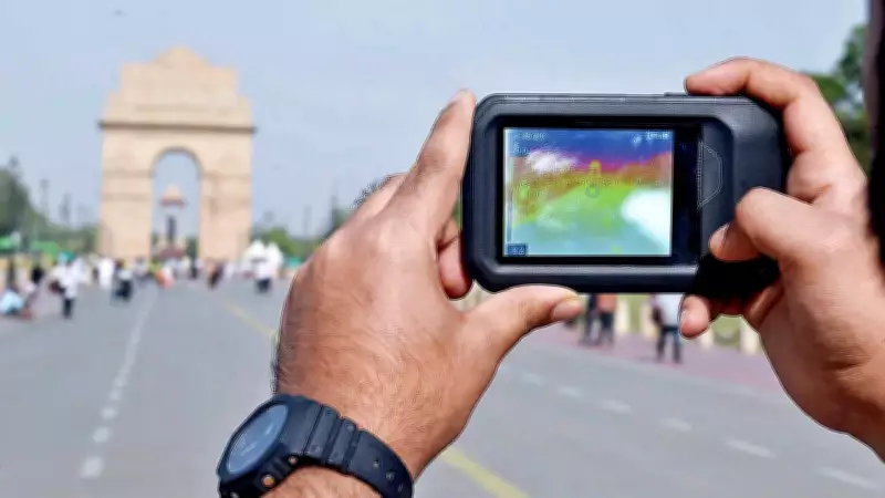
Delhi's weather app may report a temperature of 42°C, or a feels-like temperature of 44°C, labeling it as severe heat. But step onto a sun-baked pavement, sit inside an auto, wait at a bus stop, or walk through a densely built market, and the city can feel far hotter. Thermal images captured by Greenpeace India during an ongoing heat-mapping exercise are revealing a different picture of Delhi's summer – one where surface temperatures in some areas are crossing 60°C, turning everyday urban spaces into heat hotspots.
One such image, captured by climate and energy campaigner Aakiz Farooq from inside an auto, showed ambient temperatures touching 60°C, offering a glimpse of what commuters and outdoor workers experience daily. Greenpeace India is currently mapping temperatures across markets, roads, bus stops, resting areas, and dense neighborhoods to build a thermal profile of Delhi, making a strong case that Delhi's heat is not felt equally. In the first leg of thermal mapping, the campaigners have covered the Sunder Nagri area.
Concrete-Heavy Spaces Trap Dangerous Levels of Heat
Early observations suggest that highly concretized areas with little shade, ventilation, or green cover are emerging as some of the hottest parts of the city. Roads, pavements, and public resting spaces retain and radiate heat long after peak hours. In a tweet, Aakiz wrote, "We underestimate what extreme heat does to the human body. We should start asking who is responsible for this rising heat and are those more vulnerable and exposed to extreme heat responsible for the rising heat."

The work ties into the Urban Heat Island effect, where cities become hotter than surrounding regions because concrete, asphalt, and built infrastructure absorb and retain heat while reduced vegetation lowers natural cooling.
What is the Urban Heat Island Effect?
Urban areas become hotter than surrounding regions because materials such as concrete and asphalt absorb and slowly release heat, while reduced vegetation lowers natural cooling. The result – roads, roofs, and built-up neighborhoods remain hotter for longer, especially at night.
Extreme Heat Should Be Recognized as a Disaster
For many Delhiites, heat means staying indoors or turning on air conditioners. But for street vendors, delivery workers, sanitation staff, gig workers, commuters, and others who spend long hours outdoors, exposure is constant. Communities in dense neighborhoods with limited access to trees, shade, ventilation, and cooling infrastructure face higher thermal stress, making heat not just an environmental issue but also one of public health and equity.
Climate and energy campaigner Aakiz Farooq explains, "Heat is not experienced equally. As heatwaves become more frequent and intense due to climate change, heat mapping is becoming an important tool for understanding who is most exposed, which areas are most vulnerable, and how cities like Delhi can adapt to rising temperatures more inclusively and sustainably."
Extreme Heat is Becoming an Urban Planning Emergency
Greenpeace India, in the concept note of their thermal mapping initiative, states, "The mapping exercise is making a broader argument: that extreme heat should be recognized as a disaster, allowing stronger institutional response systems and dedicated adaptation funding. It raises larger questions for Delhi's future urban planning – whether public infrastructure, housing, mobility systems, and open spaces are being designed for rising temperatures."