The devastating plane crash on Wednesday that claimed the lives of deputy chief minister Ajit Pawar and four other individuals has ignited serious concerns about aviation weather protocols across India. Specifically, attention has turned to the pre-flight weather briefing procedures for chartered aircraft and the visibility conditions during landing operations at smaller airstrips.
Charter Flight Weather Briefing Gap Exposed
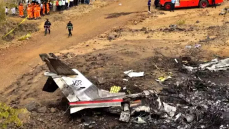
The Learjet 45 aircraft, which departed from Mumbai and crashed near the Baramati airstrip, was operating as a non-scheduled charter flight. According to senior officials from IMD's civil aviation services division, this category of aircraft does not receive direct weather briefings from the India Meteorological Department.
"Baramati airstrip lies outside IMD jurisdiction and does not have any meteorological office on site. We don't provide services there," an official explained, noting that it was a small, non-commercial facility primarily used for private and temporary landings.

Contrast with Major Airport Procedures
This situation stands in stark contrast to major Indian airports where IMD units provide comprehensive weather bulletins covering cloud cover, visibility, and other critical aviation parameters for both departure and arrival points. For non-scheduled and charter flights, pilots typically rely on IMD's Online Briefing System (OLBS), a centralized platform operated by IMD offices at international airports in Chennai and New Delhi.
Access to this system requires airline registration and approval from the ministry of civil aviation. "National carriers get official OLBS accounts through proper procedures," the official stated. "Charter operators with accounts can log in and obtain all weather data themselves. But we don't know whether this particular aircraft was registered or accessed the system."
Visibility Concerns at Baramati Airstrip
While scheduled and VVIP flights receive direct IMD briefings, charter operators depend mainly on the self-service online portal. A PIB press release indicated that when the aircraft contacted Baramati, airfield staff reported calm winds and visibility of approximately 3,000 meters (about 3km).
A former IMD official with aviation experience suggested this visibility might have been inadequate for safe operations. "Visibility should be above 5km for safe landing," the expert emphasized, noting that landing decisions ultimately rested with pilots and Air Traffic Control (ATC), and vary depending on aircraft specifications.
Unique Challenges of Table-Top Airports
Smaller airstrips like Baramati, which lack on-site IMD offices, rely on ATC's own equipment for weather updates. "Such airfields generally do not issue METARs, the standardized half-hourly weather observations used widely in aviation," the official explained.
According to a DGCA statement on Wednesday, Baramati is classified as an "uncontrolled airfield" where traffic information is provided by instructors or pilots from local flying training organizations. Baramati is also categorized as a table-top airport, located on elevated terrain.
IMD officials highlighted that such airports pose additional risks to aviation safety. "Table-top airports are situated on small hills, above sea level. Their runways are often shorter than those at major airports, reducing the margin for landing and taxiing," another IMD official detailed, pointing to the compounded challenges of limited infrastructure and weather monitoring capabilities.
The tragic incident has brought renewed focus on the need for enhanced safety protocols and weather monitoring systems at India's smaller aviation facilities, particularly those serving charter operations and located in challenging geographical settings.